
The Roman-African borderlands and expeditions south of the Sahara.

After the fall of Carthage in 146 BC, the Roman Empire came into direct contact with a number of African states with whom it shared a long and open frontier extending from the northwestern tip of the continent to the Red Sea coast.
Over the following two centuries, a shifting pattern of alliances and conflicts along this frontier gradually reshaped the political landscape.
Polities such as the kingdoms of Numidia and Mauretania (in northern Algeria and Morocco) were gradually incorporated into the Roman sphere, the Ptolemaic Kingdom in Egypt was defeated, while the Kingdom of Kush (Sudan) successfully resisted Roman expansion.
This period of sustained military and diplomatic activity led to the dispatch of a number of expeditions into the African interior, whose itineraries south of the Sahara remain a subject of intense debate.
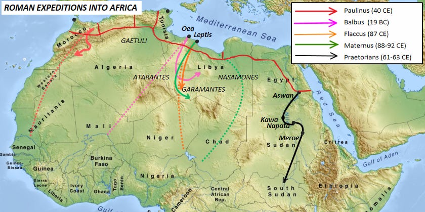
Roman Expeditions into Africa, Map by Author.
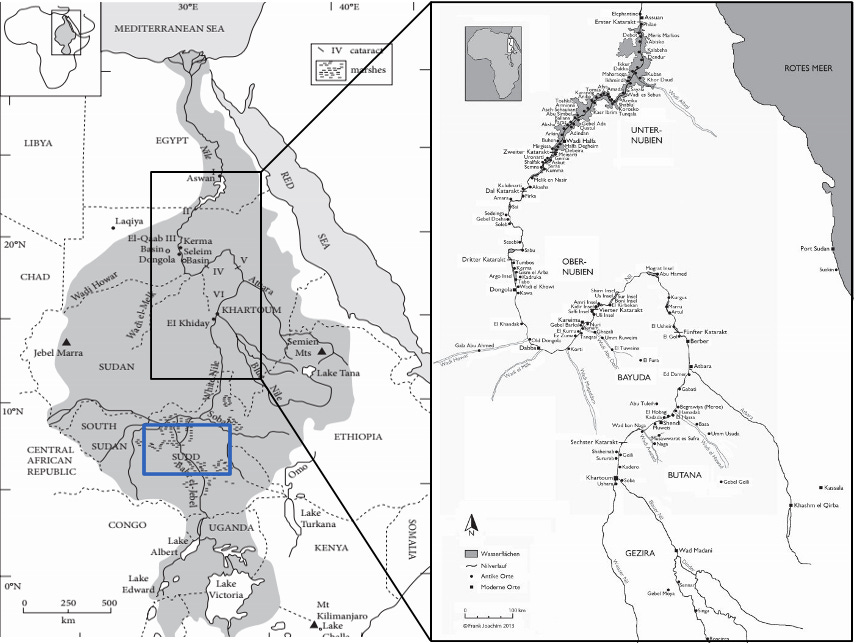
The least disputed of these was the journey undertaken by Praetorian guards down the Nile River between 61 and 63 CE. The Praetorians were sent by the emperor Nero on a reconnaissance expedition to assess the region for a potential conquest. The project was ultimately abandoned, apparently because of the region’s arid environment. (Pliny, N.H. 6.181-2)
Starting from Aswan in Egypt, they traveled through Hiera Sycaminos (Maharraqa), Tama (Gezira), Primis (Amara), Acina (Tagab), Pitara (Kawa), Gagaudes (Megauda), Articula Island, Tergedum (Tergis), Napata, and then to Meroe, the capital, which was “ruled by a woman, Candace.”
Pliny’s account (N.H. 6.183-9), which provides fairly accurate names of Kush’s cities and distances between them, ends at this point and says nothing about the regions farther south.1
This southern portion of the journey is instead described by Seneca (NQ 6.8), who claims that Nero’s expedition sought to discover the source of the Nile. Seneca does not provide a detailed itinerary for the centurions, but notes that a king ruled at Meroë and “supplied them with assistance and furnished letters of introduction to the neighbouring kings.” The explorers then reached “huge marshes,” where the river was so entangled with vegetation that it could not be navigated by boat or traversed on foot.
Both accounts are generally accepted by scholars of Nubian history as reflecting genuine expeditions into the middle Nile region, especially the itinerary provided by Pliny. Seneca’s account, while less detailed, nevertheless appears to describe with some accuracy the Sudd, the vast marshland in what is now South Sudan.2
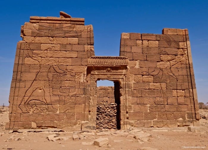
Apedemak temple at Naqa, Sudan, depicting the co-regents Queen Amanitore and King Natakamani smiting their enemies. The Queen is thought to have reigned around the time of Nero (54-68 CE).
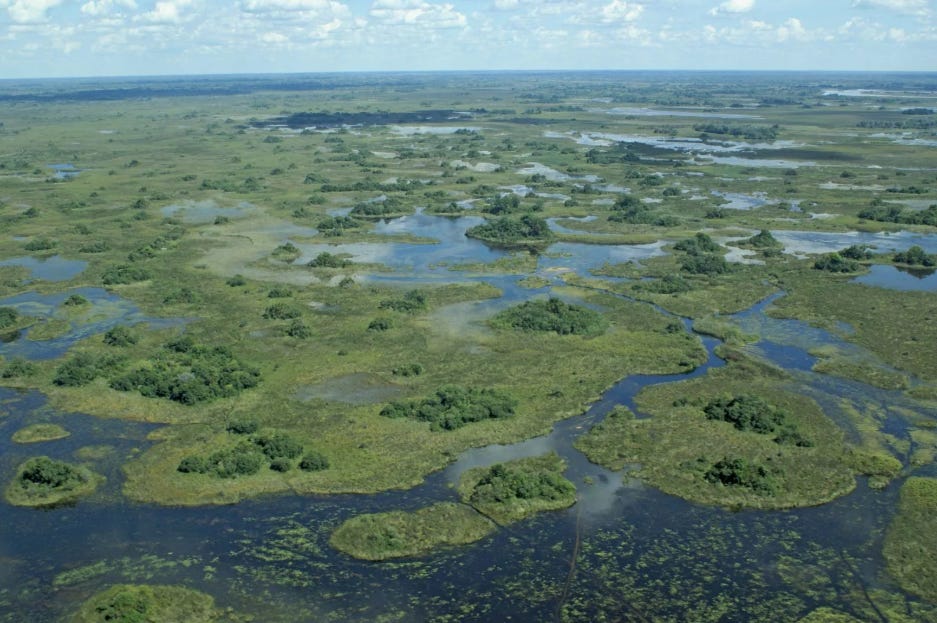
The Sudd wetland of South Sudan.
Extent of the kingdom of Kush based on known archaeological sites.
The itineraries for the rest of the Roman expeditions into Africa are dubious and poorly-defined.
Claims that the campaigns of Lucius Cornelius Balbus in 19 BC extended southwards as far as the Niger River in modern Mali are rejected by specialists such as David Mattingly and Thomas Insoll. Balbus’ campaign against the Garamantians of S.W Libya, for which Pliny provides a detailed itinerary of towns in the Fezzan region (NH 5.35–7), was confined to Libya and was solely concerned with the pacification of the region.3
Pliny also provides an account of Rome’s westernmost expedition by Suetonius Paulinus in 40 CE, who crossed the Atlas mountains until he reached a river called Ger (NH 5.14). It is often claimed that this river might have been the Senegal River, a hypothesis based largely on speculative etymological grounds.
This interpretation, however, has been rejected by specialists in the history of north-west Africa, who maintain that Paulinus probably did not travel beyond the Guir River of southern Morocco, and that his attempt to pacify the interior of Mauretania ultimately failed. A further expedition to subdue Mauretania was dispatched the following year under his successor, Gnaeus Hosidius Geta.4
[**The Roman province of Mauretania was located on the northern tip of Morocco and Algeria, and should not be confused with the modern country of Mauritania.]
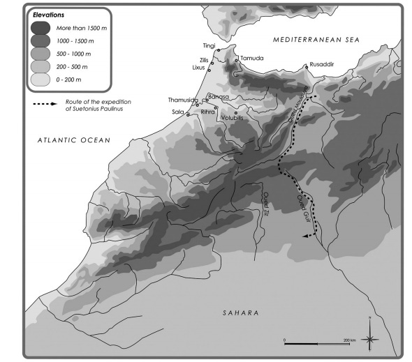
Map showing the route of the expedition of Suetonius Paulinus. Map by R. A. Messier and J. A. Miller.
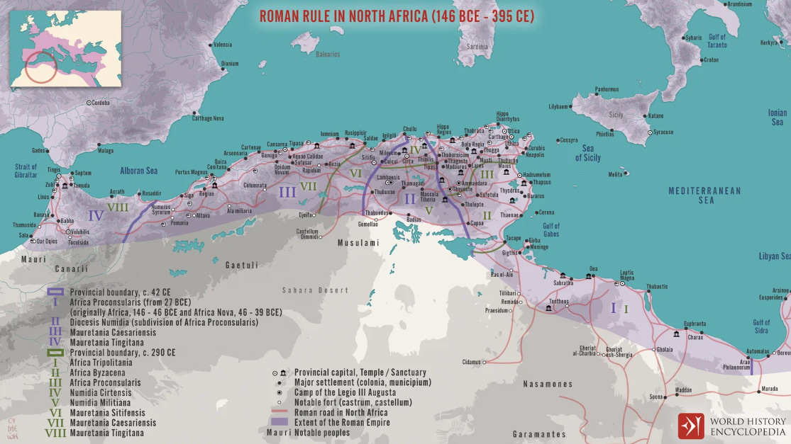
Map of Roman North Africa (146 BCE - 395 CE) By World History Encyclopedia
In the second half of the 1st century CE, three expeditions were sent into and beyond the Garamatian territories in close succession.
The first of these was undertaken by Septimius Flaccus and Valerius Festus as part of a pacification campaign following the war between Lepcis and Oea in 69 CE. Festus’ journey, which is mentioned by Tacitus (Hist. 4. 49-50) and Pliny (NH 5.38), only describes a campaign to recover stolen booty from the Garamatians, “except what the nomads had already sold among the inaccessible hut-settlements of the far interior.”
Nothing is said of a southern expedition, across the Sahara, certainly not to Timbuktu or Nigeria, as is at times speculated.
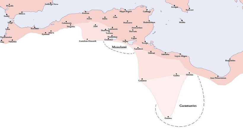
Map of the Roman provinces in north Africa during Septimius Severus's reign in the late 2nd century AD, showing the extent of the Garamantian kingdom
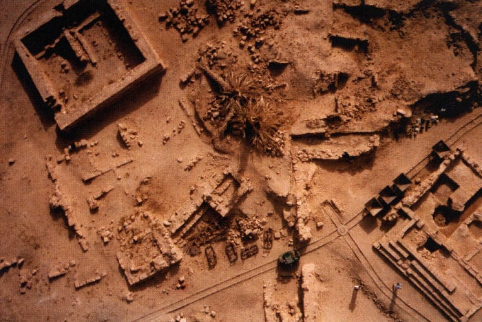
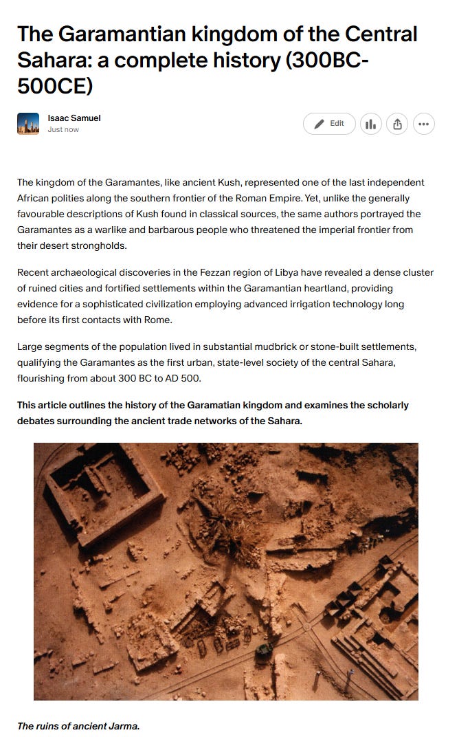
The ruins of ancient Jarma. Image by D. Mattingly.
The 2nd century account of Claudius Ptolemy (Geog. 1.8), who quotes the geographer Marinus of Tyre, stated that Septimius Flaccus took 30 days to reach the Garamatian capital with his army and then marched south to the land of the Aithiopians. A few years later, he was followed on this route by a certain Julius Maternus who proceeded south in the company of the Garamantian king on a journey of three months to the land of Agisymba ‘where the rhinoceros is to be found’.
Ptolemy strongly rejects the veracity of the account describing a three-month journey to the south, arguing that these men simply “told travelers’ tales.” This criticism is based on his own view that the Garamatians were themselves Aithiopians, had the same king as the latter, and were distributed primarily along an east–west axis. According to Ptolemy, Marinus’ informants may therefore have mistaken this latitudinal distribution for a north–south extension.5
The historical evidence for Roman expeditions south of the Sahara is thus disappointingly limited and highly speculative.
Many of the accounts traditionally interpreted as descriptions of long exploratory journeys were, in reality, relatively brief military expeditions directed against known polities situated along the southern frontier of the Empire, such as Mauretania (in Morocco) and the Garamantes in Libya.
Modern scholars who accept Marinus’ account and disregard Ptolemy’s criticism, argue that the two expeditions of Flaccus and Maternus reached the Lake Chad region as part of an ancient Trans-Saharan trade controlled by the Garamantian kingdom.
The kingdom of the Garamantes, like ancient Kush, represented one of the last independent African polities along the southern frontier of the Roman Empire. Yet, unlike the generally favourable descriptions of Kush found in classical sources, the same authors portrayed the Garamantes as a warlike and barbarous people who threatened the imperial frontier from their desert strongholds.
Recent archaeological discoveries in the Fezzan region of Libya have revealed a dense cluster of ruined cities and fortified settlements within the Garamantian heartland, providing evidence for a sophisticated civilization employing advanced irrigation technology long before its first contacts with Rome.
Large segments of the population lived in substantial mudbrick or stone-built settlements, qualifying the Garamantes as the first urban, state-level society of the central Sahara, flourishing from about 300 BC to AD 500.
My latest article on Patreon examines the history of the Garamantes and the scholarly debates surrounding the ancient trade networks of the Sahara.
Please subscribe to read about it here:
The Kingdom of Kush: Handbook of the Napatan-Meroitic Civilization By László Török pg 417
The Kingdom of Kush: Handbook of the Napatan-Meroitic Civilization By László Török, pg 464, The Oxford Handbook of Ancient Nubia, edited by Geoff Emberling and Bruce Williams, pg 707.
Tripolitania By David J. Mattingly 114-115, The Archaeology of Islam in Sub-Saharan Africa By Timothy Insoll, pg 211
The Last Civilized Place: Sijilmasa and Its Saharan Destiny by Ronald A. Messier, James A. Miller, pg 66-68
Ptolemy’s Geography An Annotated Translation of the Theoretical Chapters, pg 67-68, 70.
Thank you for this interesting article that shows again how intertwined are African and European history.