
The desert town of Southern Africa: A history of Khauxanas 1780-1906
A view of pre-colonial Namibia from the khoisan town of ||Khauxa!nas.

Located deep in the harsh deserts of southern Namibia, the ruined town of khauxanas was at the center of a fascinating chapter in southern Africa's political history.
Founded around the late 18th century by the Orlam clan of the Nama Khoisan, the 5-acre stone settlement of Khauxanas straddles several important historical events in the region's history. From the Orlams' resistance movement against the cape colony, to the founding of Namibia's capital Windhoek, and the anti-colonial war between the Nama and the Germans —the history of Khauxanas provides an excellent example of Nama processes of state formation and colonial resistance.
This article explores the history of Khauxanas and its place in the political history of south-western Africa.
Map of south-western Africa showing the movement of the Orlams and the location of ||Khauxa!nas

Support AfricanHistoryExtra by becoming a member of our Patreon community, subscribe here to read more about African history, download free books, and keep this newsletter free for all:
A brief History of the Orlams: Nama independence on a colonial frontier
For most of south-western Africa’s history, the region’s semiarid lands were home to the speakers of Khoisan language families, among which the largest family was the Khoe-Kwadi, which included the Nama languages1. The section of the Nama-speakers who are associated with old settlements of ||Khauxa!nas and Windhoek, are commonly described under the collective name of Oorlam/Orlam.
The Orlams were a heterogeneous lineage group of predominantly Nama extract who were first attested in the vicinity of the witzenberg mountains (near Tulbagh, south Africa) around the time of the cape colony's establishment.2 The Orlams were the first to refer to themselves as Afrikaner/Afrikanner/Afrikaander and use it as their last name, more than a century before it was adopted by the Dutch-speaking settlers of cape colony who were at the time called Boers/Boors. They are therefore the only group which appears in early 19th century accounts under that ethnonym.3
The term "Africander" which is derived from the exonymous term for the African continent by Dutch-speakers of the cape colony, was first used as a collective term for the groups born to cape settlers and Africans. However, the Orlam Afrikaner clan which first used it as their name were not part of this group of mixed heritage, as they were mostly of Nama descent with some San ancestry, and their lands weren't considered part of Cape colony before the mid-18th century.4
The Orlam first attracted official attention in the letters dated to 1761 written by Adam Kok, a cape official in the vicinity of the modern town of Tulbagh. According to Kok, a Nama man nicknamed "Oude ram" and his son Afrikaner were contracted to look after the livestock of a cape settler named Nicolaas Laubser. Both Oude and Afrikaner were under the supervision of Kok and a Nama man named 'Klaas' who went by the name "Captain Klaas" due to his rank. A dispute over Afrikaner's handling of the livestock led to Kok reprimanding him, but Captain Klaas sided with the former. Shortly after; Afrikaner and Oude ram fled with Captain Klaas to the countryside to raise a rebellion among the Nama, but they were later captured and exiled, with Afrikaner dying in 1777. However, Captain Klaas was allowed to stay, and it was during the period between Afrikaner's death and the first mission to his base in 1805, that Klaas and his sons begun using the name Afrikaner.5
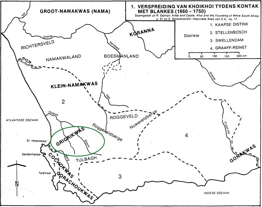
Map showing the distribution of various KhoeKhoe lineage groups as known by cape settlers, The Orlams originated from the Grigrikwas/Griquas.6
The founding of ||Khauxa!nas by the Orlams clan. (1780s-1823)
A series of political changes and social upheavals in which Klaas was involved led to his creation of a resistance movement against cape authorities and likely informed Klaas' use of the name of his precursor; Afrikaner. During the 1780s, the family of Captain Klaas had stayed in Tulbagh in the service of a cape settler named Petrus Pienaar. Klaas maintained a mostly cordial partnership with Pienaar whose interests extended as far north as the orange river. Klaas received firearms for his services, and was in close contact with cape authorities. But a personal dispute ended with the death of Pienaar in 1796 by one of Klaas' sons, forcing the clan to flee beyond the orange river inorder to escape the commandos (armed parties) sent by the cape authorities to capture them.7
Klaas Orlams withstood and conducted several attacks against both the cape settlers and surrounding settlements from his secretive hideout, which according to the cape authorities, lay north of the orange river. From here, he gathered a relatively large following among disaffected Nama and san groups, and merged his activities with some southern groups in the cape colony districts of Swellendam and Graaff-Reinet that were rebelling against cape authorities.8
The secretive hideout of the Klaas' Orlams clan when he retreated north of the Orange river, was most likely located in the inaccessible Karas Mountains; where the clan established ||Khauxa!nas as their hidden refuge. This town was most likely constructed in the last decade of the 18th century, and served as the Orlams’ capital until the early 19th century. 9
By the early 19th century, Klaas was actively assisted by his son Jager and soon handed over the leadership to him. Jager succeeded in re-establishing peaceful contacts with the cape authorities, and invited the LMS missionaries Abraham and Christian Albrecht in 1803. The missionaries were met by Jager in 1805 at a place called Afrikanerskraal (later nicknamed Jerusalem), where a mission station was established at a distance away from ||Khauxa!nas, before it was later moved 90km south to the town of Warmbad in 1806. By 1815, Klaas' 6 sons would later take on more names such as; Christian (Jager), Titus, Hendrik, Jakobus, Simon and Klaas after adopting christianity.10
Missionary activity remained confined to the south of Warmbad, and was thus well outside the region controlled by the Orlams11, explaining why no records of the site exist from the LMS accounts. After a brief period of disputes between the missionaries at Warmbad and the Orlams, By 1819, Jager had re-established peaceful relations with both Warmbad and the cape authorities through the offices of one of the missionaries12. Jager passed away in 1823 and was succeeded by his son Jonker Afrikaner who, after gaining more followers and wealth, moved the Orlams clan northwards and established the settlement of Windhoek in the 1830s.13

Jan Jonker Afrikaner and his council, ca. 1876. Jan Jonker was the son of Jonker Afrikaner and later took over leadership of the Orlams.
||Khauxa!nas after its abandonment by the Orlams
The relatives of Jonker Afrikaner, named David and Titus Afrikaner, later broke off from the Orlams at Windhoek and returned to the region of Afrikanerskraal where they invited missionaries form the Welseyan mission at Warmbad, which had replaced the LMS.14
The Welseyan mission station at Warmbad was by then headed by Benjamin Ridsdale during the 1840s, who would later be succeeded by John A. Bailie. Both of them were active among various Nama and San groups occupying the regions north of the Orange river and east of the Great Karas mountains . They visited David and Titus Afrikaner at Afrikanerskraal (Jerusalem) as well as the nearby settlement at Blydeverwacht, after the former settlement had shortly been abandoned. David also occasionally travelled to visit Jonker more than 600 miles north at Windhoek, with whom he reconciled.15Such a journey underscores the extreme mobility that characterized the cultural patterns of the Nama, and the Orlams in particular.
The region around the site of ||Khauxa!nas was during this time occupied by a section of the Namas called the ||Hawoben (rendered Veldschoendragers in Dutch and 'Velschoen Draagers' in Ridsdale's account). Like all highly mobile pastoral Nama groups, they had been previously settled at a site called Klip Fontein, which most likely corresponds to the ruins on the modern farm of Narudas.16
Among the settlements of the ||Hawoben visited by Ridsdale in 1847 was one called "Schans Vlakte", which was located at the foot of a low mountain (ie; the mountain of ||Khauxa!nas). Shans Vlakte was led by a Nama chief named Hendriks (Nama name: !Nanib gaib), whose followers had constructed a road to receive the wagons of Ridsdale. The remains of this town now mostly consist of a few drystone homes and the walls of a church that were constructed with mortared stone. ||Khauxa!nas is the Nama name for the local region including the mountain, while the present farm in which the ruins are located is called Schanzen, derived from the German rendering of “Schans Vlakte”.17
Risdale then describes the ruined settlement at the top of the hill:
"... In front of the village is a low mountain, which is surrounded at the top by a wall, the entire length of which must be eight or ten hundred yards, low in places difficult to access, and five or six feet high in those parts that are most easily available. This wall, which consists of a double row of loose flat stones piled one above another, was thrown round the mountain by the Afrikaners at the beginning of the century. After shooting of the Dutch Boer, Pinnar, to whom old Afrikaner and his clan were at that time subject, and by whom they were oppressed beyond all endurance, Afrikaner and his people fled to this place. Here they resolved upon making a stand against the commandoes sent in pursuit of them by the Colonial Government. Within this entrenchment, at the top of the mountain, they built their houses, had kraals for their calves, and in fact everything necessary to a Namaqua village, and considered themselves able to defy all their enemies. They seemed scarcely able to conceive of avalour that would proceed in the face of their bullets, scale their fort, bound over its walls, drive them over the fearful precipice on the opposite side, and plunge them into the abyss of black waters beneath. The opportunity of defending themselves in their impregnable fortification, however, never occurred, as the commandoes of Boers from the Colony pursued them no farther than Nisbett Bath (Warmbad)."18
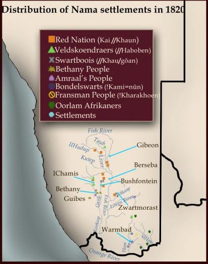
Map showing the distribution of Nama settlements in the early 19th century19
Description of the town.
The Orlam ruins of ||Khauxa!nas were built on the crest of the ||Khauxa!nas mountain, within the modern farm of Schanzen 281, east of the Great Karas Mountains. The entire settlement is surrounded by a high elliptical stone wall that is 700m long, 2m high and about 1m thick. The walls enclosed public spaces, household units and cattle kraals, all of which were accessed through narrow artificial alleys leading to individual entrances. With the exception of three rectilinear structures, most domestic structures were roundhouses, paved with flat stones, roofed with non-permanent materials, and drained through culverts on the floor. The rectilinear buildings all located at the entrances of the southern wall and northern walls, they likely served as a reception or a guardhouse.20

Plan of the hilltop ruins at //Khauxainas21


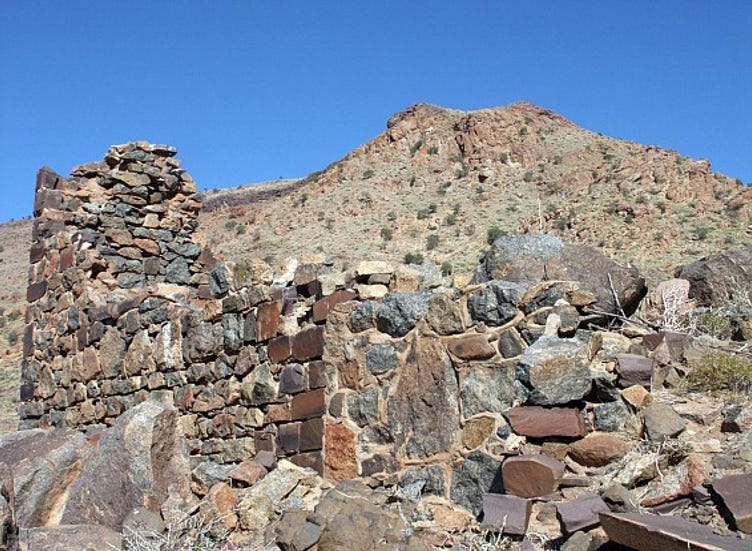
Perimeter wall in the highest point and the remains of household units.
There are three phases of occupation and construction. The earliest consists of a few roughly built windbreaks and hut circles associated with short lengths of walling that may have formed part of a livestock enclosure and a defensive structure.22 The second period comprises the major walled structures of the Orlam settlement, while the last phase corresponds to the resettlement of the site during the first decade of the 20th century.23
Evidence for social stratification at the settlement is indicated by the presence of a large structure about 10 meters in diameter with ostentatious architectural features facing the southern wall's rectilinear entrance. This structure likely served as the residence of ||Khauxa!nas's founder. Considering the presence of a similar household layout associated with the two reception houses on the northern wall, the latter structures were likely occupied by second level authority figures in the settlement.24

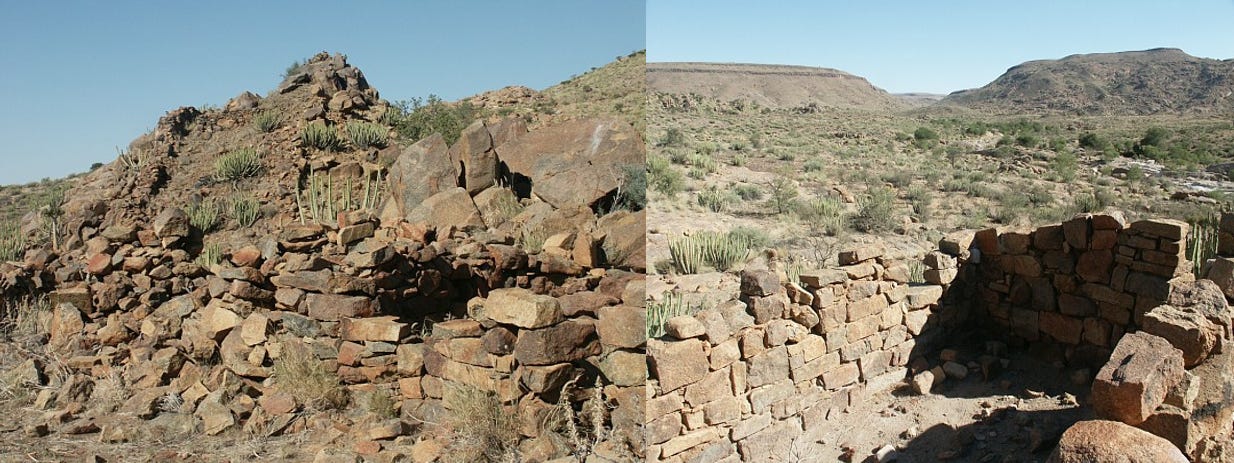
Ruins of a large house, probably occupied by Klaas Afrikaner

funerary stela and drainage openings
Most of the settlement likely served non-defensive functions such as enclosing houses, protecting livestock and symbolic/political functions that reflected the Orlams' hegemony in the region. Despite the visible remains of gunflints which understate its military function, the presence of 22 entrances along the 700 meter perimeter wall would have made the settlement difficult to defend. The northern and eastern sections of the wall consist of a series of contiguous household units, facing toward the central part of the settlement. Considering its size, its population and the amount of settlement debris, the town was unlikely to have been occupied for long -possibly no more than a decade.25
Similar dry-stone settlements built by the Nama include the abovementioned site at Narudas. The ruins at Narudas share several similarities with the construction style of ||Khauxa!nas, especially the ubiquity of funerary stela. In describing the settlement at Schans Vlakte, Ridsdale's successor John A. Baile writes that "In this country are to be seen, here and there, the old "Schansen" or Namaqua Forts, and some curious tombs raised in memory of some of their bravest warriors. These tombs are formed of choice stones from four to six feet long, placed perpendicularly with one end in the ground, and within a few inches of each other". 26
||Khauxa!nas’ basic aggregation pattern in which household units were arranged around a common livestock enclosure, follows a common settlement style in southern Africa27 similar to the "central cattle pattern" of south-western Africa.28Similar forms of dry-stone pastoral settlements, some of which also include well defined road systems like that seen by Ridsdale are best attested in the sotho-tswana towns like Kaditswhene, in the towns of Bokoni and in the Shona cities like Great Zimbabwe.
Narudas ruins, Namibia.29
||Khauxa!nas as an anti-colonial base: Marengo’s war against the Germans 1904-1906
Following the death of Schans Vlakte's chief !Nanib, the chieftaincy of the ||Hawoben would be assumed his brother, who also moved north to join Jonker Afrikaner's burgeoning settlement at Windhoek, which would later become Namibia's capital.
The town of ||Khauxa!nas remained largely abandoned for most of the second half of the 19th century, during the early phases of Namibia’s colonization by the Germans. The ruins were then re-occupied by the forces of Jakob Marengo during the brutal colonial war between the Nama and the Germans from 1903-09. Marengo, who referred to ||Khauxa!nas as "Kactchanas", used the barren and inaccessible terrain as a safe haven to elude pursuit by the German forces.30
Marengo's armed party of no more than a hundred soldiers, inflicted repeated and ignominious reverses on the German Army for over two years from 1904-1906, tying down over 15,000 German soldiers in southern Namibia. His guerrilla warfare tactics relied alot on fortifying himself in the pre-existing settlements of ||Khauxa!nas and Narudas, the latter of which was identified by the Germans as "Morenga's fortress". Eventually, however, the build-up of troops and armaments forced him to momentarily withdraw across the border into British territory. After a series of failed negotiations (likely conducted at ||Khauxa!nas) and further battles, Marengo fled south and surrendered to the British cape police.
The desert town of ||Khauxa!nas later faded into obscurity, until the area began to be studied by Klaus Dierks in the 1980s.

The Rectangular Building in ||Khauxa!nas: "Marengo's House"
The continent of Africa is separated from China by more than 7,000 km of ocean. But despite the seemingly insurmountable chasm between the two regions, There are over a dozen documented visits by Africans and Chinese visiting each others’ lands across 2,000 years of history. Read more about this fascinating history here:

If you liked this article, or would like to contribute to my African history website project; please support my writing via Paypal
Beyond Khoisan: Historical Relations in the Kalahari Basin by Tom Güldemann, pg 1–40, A linguist’s view: Khoe-Kwadi speakers as the earliest foodproducers of southern Africa by Tom Güldemann
The Supreme Being of the Khoi-khoi By Theophilus Hahn pg 96-97, Die geskiedenis van die Afrikaner-Oorlams by P Stoffberg pg 19)
Besides the 18th century documents discovered by Stoffberg and Dierks which refer to the Orlam Afrikaners, the following books from the 1820s contain the first use of the name exclusively by Klaas and his relatives; “Schets van het leven van Afrikaner”, 1826, by N. Cornel, '“Researches in South Africa”, 1828, by John Philip, pg 130, “Travels in the Interior of Southern Africa”, Volume 2, 1824, by William John Burchell, pg 376
State of the Cape of Good Hope in 1822 By W. Bird pg 73, Die geskiedenis van die Afrikaner-Oorlams by P Stoffberg pg 20-21)
Die geskiedenis van die Afrikaner-Oorlams by P Stoffberg 22-24)
map by P Stoffberg
Die geskiedenis van die Afrikaner-Oorlams by P Stoffberg pg 26-35, 45-69, 73-82)
The Politics of a South African Frontier by By Martin Chatfield Legassick pg 71-73, History of South Africa 1795-1834 By George McCall Theal pg 48 (Theal claims it was located on an island in the orange river but doesn’t provide evidence to back the claim)
Chapt. 3 of ||Khauxa!nas - The Great Namibian Settlement by Klaus Dierks
Die geskiedenis van die Afrikaner-Oorlams by P Stoffberg pg 21-22, 97-105)
Die geskiedenis van die Afrikaner-Oorlams by P Stoffberg pg 138-170)
Hate the Old and Follow the New: Khoekhoe and Missionaries by Tilman Dedering pg 101-105
The Archaeology of Social Rank among Eighteenth-Century Nomadic Pastoralists in Southern Namibia by John Kinahan, pg 240, chapter 3 of ||Khauxa!nas - The Great Namibian Settlement by Klaus Dierks
Extracts from the Letters of James Backhouse Vol.2 pg 49-52
Scenes and Adventures in Great Namaqualand By Benjamin Ridsdale pg 152,155, 224)
(Scenes and Adventures in Great Namaqualand By Benjamin Ridsdale pg 252-254, 167, chapter 3 of ||Khauxa!nas - The Great Namibian Settlement by Klaus Dierks
Scenes and Adventures in Great Namaqualand By Benjamin Ridsdale pg 274, chapt 2 of ||Khauxa!nas - The Great Namibian Settlement by Klaus Dierks
Scenes and Adventures in Great Namaqualand By Benjamin Ridsdale pg 276)
Map by By Jeroen Zandberg
The Archaeology of Social Rank among Eighteenth-Century Nomadic Pastoralists in Southern Namibia by John Kinahan pg 234-235, 237-238, chapt 2 of ||Khauxa!nas - The Great Namibian Settlement by Klaus Dierks
Plan by John Kinahan
The Archaeology of Social Rank among Eighteenth-Century Nomadic Pastoralists in Southern Namibia by John Kinahan 232-233,
chapt 2 and 3 of ||Khauxa!nas - The Great Namibian Settlement by Klaus Dierks
The Archaeology of Social Rank among Eighteenth-Century Nomadic Pastoralists in Southern Namibia by John Kinahan 238-239)
The Archaeology of Social Rank among Eighteenth-Century Nomadic Pastoralists in Southern Namibia by John Kinahan pg 236-237)
chapt 3 of ||Khauxa!nas - The Great Namibian Settlement by Klaus Dierks
The Archaeology of Social Rank among Eighteenth-Century Nomadic Pastoralists in Southern Namibia by John Kinahan pg 240
Badenhor’s critique of Huffman’s CCP model included an example of cattle at the center of a KhoeKhoe settlement, indicating that CCP wasn’t just used by bantu-speakers, but was instead used by all southern african groups for its functionality: “Debating the central cattle pattern by T. Huffman, pg 166”
chapt 2 of ||Khauxa!nas - The Great Namibian Settlement by Klaus Dierks