
The Luo Migrations: Reassessing “Stateless” Societies in Pre-Colonial Africa

Africa occupies a foundational place in the development of modern political anthropology. It was through studies of African societies during the 1940s and 1950s that scholars such as Evans-Pritchard and Aidan Southall first formulated influential classifications of “early states,” “segmentary states,” and stateless societies.
These models, which later became highly influential among social scientists studying non-Western societies, were based largely on research conducted among Luo-speaking communities in South Sudan, Northern Uganda, and Western Kenya.
The Luo constitute one of Africa’s most widely dispersed population groups, following a major wave of migration during the 16th century that profoundly reshaped the cultural and political history of East Africa.
Initially classified as “stateless” societies situated on the periphery of the centralised, mostly Bantu-speaking states of the Great Lakes region, Luo societies later became the archetypal examples of “segmentary” political organisation.
However, the history of the Luo societies suggests that these classifications do not sufficiently describe the evolution of their political systems since the 16th century. These models instead describe societies already transformed by the external disruptions of the late 19th century, such as the Turkish-Egyptian invasions, which altered pre-existing forms of social organisation.
This article outlines the history of the Luo migrations and examines the evolution of their political systems since the 16th century, showing how Luo forms of social organisation shifted between these different systems over time.
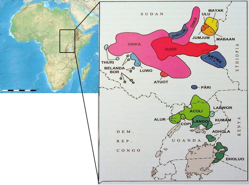
Distribution of Western Nilotic languages in East Africa. Map by Anne Storch
Support African History Extra by becoming a member of our Patreon community. Subscribe here to read more about African history, download free books, and keep this newsletter free for all:
Shilluk and the End of Medieval Nubia: Reconstructing the Luo Migrations
In 1497, an enigmatic African group known as the Funj overran the medieval Nubian kingdom of Alodia and established their capital at Sennar, near modern Khatourm in Sudan.1
The Funj were a Nubian group whose northward movement was triggered by the arrival of the Shilluk, a section of Luo-speakers whose expansion across Eastern Africa created one of the continent’s most widely distributed population groups.
In linguistic classification, the Luo languages form the Western branch of the Nilotic languages, which are in turn part of the Nilo-Saharan family, one of the four language phyla of Africa, the others being Afro-Asiatic, Niger-Congo, and KhoiSan.
Western Nilotic is divided into three main clusters: Luo, Dinka–Nuer, and Burun. Among these, the Luo languages are the most widely spoken. They are divided into the northern languages of Shilluk, Anuak, Pari, Thuri, and Bor. And the southern languages of Acholi, Alur, Dhulou (Kenyan Luo), Copi, Adhola, Labwor, Kumam, and Lango.2
An overview of the geographic distribution of these languages is provided in the map by Anne Storch. It should be noted that the map is based on their settlement patterns from the early 20th century, but may not reflect modern population distribution, given the political upheavals since then.3
While other Nilotic groups, such as the Maasai, Dinka, and Kalenjin, also underwent major movements, the Luo expansion was particularly significant for its enduring influence on the dynastic histories and settlement patterns of both the riverine Sudan and the predominantly Bantu-speaking Great Lakes region, a process that reshaped the political landscape of East Africa.
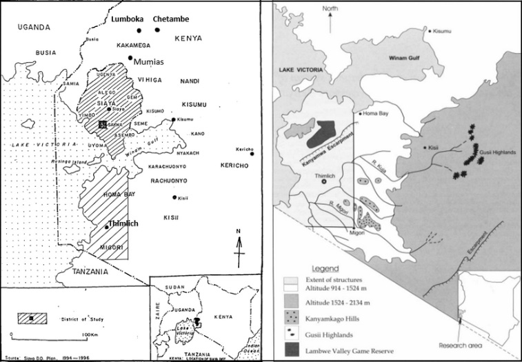
In his landmark study of southern Luo history, the historian Bethwell Allan Ogot analysed the historical traditions of twenty-two Luo-speaking groups across eastern Uganda and western Kenya.
Oral evidence in the form of genealogies, toponyms, migration narratives, religious systems, and histories of social organisation was systematically examined, cross-checked, and comparatively dated through linguistic and ethnographic research. Ogot’s work laid the foundation for subsequent scholarship, which revised many of the older structuralist interpretations and was later supplemented by archaeological research.4
The original homeland of the Luo languages is generally thought to have been located in the Bahr el-Ghazal region of north-western South Sudan. From this region, communities of semi-sedentary peoples began to expand during the mid-2nd millennium CE.
The northernmost groups, such as the Shilluk and Anuak, expanded eastwards to Wipac on the banks of the Bahr-el-Ghazal tributary, and further on to the White Nile at the start of the 16th century. Here, the Shilluk kingdom’s founder Nyikang’o’, drove out the Funj of Sennar and established his own state near Fashoda. The Anuak, who had separated from the Shilluk at Wipac, moved further east to the South Sudan/Ethiopia borderlands and founded a number of polities.5
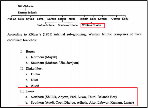
View of the mosque and houses in Sennar, Sudan (bottom), and the ruins of the house of the Funj King of Sennar (top) on the Blue Nile. Coloured engraving ca. 1834, based on a drawing by F. Cailliaud ca. 1824
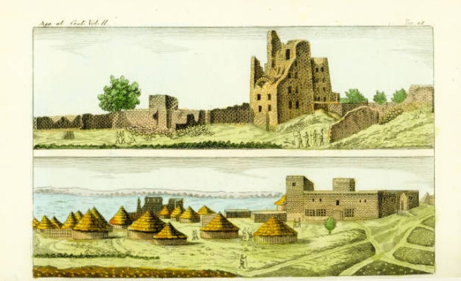
Remains of the mosque at Sennar, ca. 1910.6
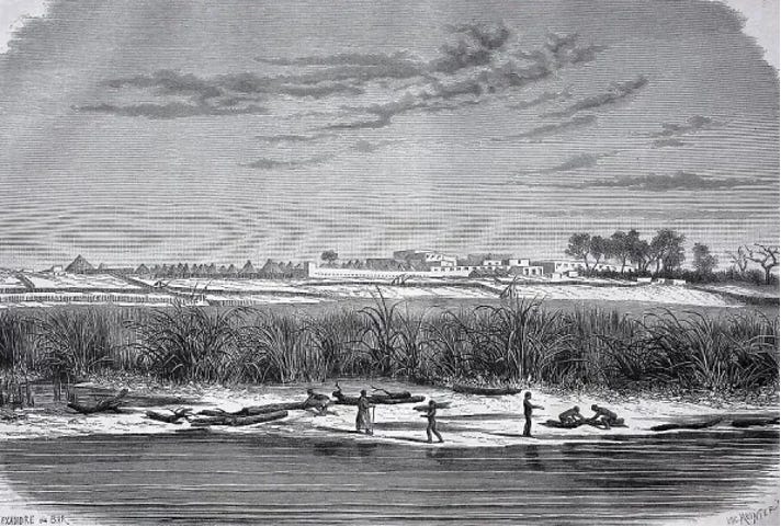
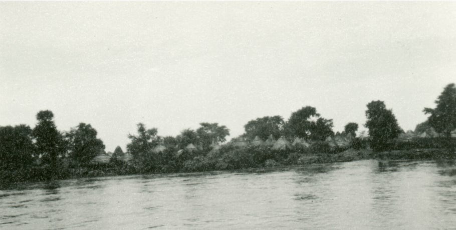
View of Fashoda from the river. ca. 1871. Image by Georg Schweinfurth
Backview of Fashoda, ca. 1910, South Sudan. Pitt Rivers Museum
Sudan provides the oldest written accounts of the Luo migrations. Historical traditions about the role of the Shilluk in the kingdom of Sennar were first transcribed by the explorer James Bruce when he visited Sennar in 1772.
Bruce recorded two conflicting accounts; the first one, which he preferred, since it came from Aḥmad Sīd al-Qom, a high officer in the Funj court and matched his own observations of Funj society, claimed that the Funj were originally non-muslim Shilluk. The second account, only found in his private journal, suggests they were Muslim converts who moved downstream from the white Nile. Later travelers would dismiss the Shilluk origin but maintain that the Funj came from the White Nile.
The Funj chronicle mentions a cradle known as Lul (Walool) along the white Nile, before their later shift to the Blue Nile region. Parts of these accounts are corroborated by traditional histories of the Shilluk, first written in the early 20th century. These describe their migration to the white Nile, as well as the displacement of the Apfuny (Funj) from their hilltop settlements to the Blue Nile.7
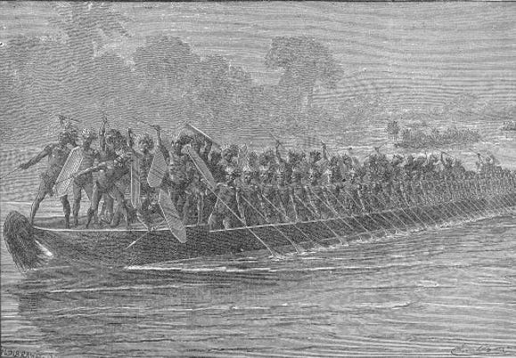
The Shilluk kingdom was centered at Fashoda since the reign of Reth (King) Tugo (r. 1690-1710), who also introduced the royal cult of the founder king Nyikang. Political institutions were centralized under the kings and nobility (kwareth ), who monopolized power, accumulated wealth, engaged in regional diplomacy and trade, and maintained an army mobilised from the lower classes and war captives.8
Their forces of war canoes and infantrymen ensured that the kingdom remained a major regional power able to hold off the Funj and their Arabised subjects.
In the early 17th century, the Dinka, another Western Nilotic group (but not Luo-speaking), expanded into the southern Gezira at the expense of both the Shilluk and Sennar kingdoms. These expansions, often gradual but occasionally resulting in war, lasted until the 18th century. While the Dinka were formidable fighters who outnumbered the armies of Sennar, they lacked a central political institution, and large-scale co-operation among the clans was impossible to maintain for long.9
The Dinka incursions forced Shilluk and Sennar into an alliance during the reigns of the Funj sultan Badi II and the Shilluk king Duwat (r. 1635-1650). This alliance was retained by their successors, particularly Reth Tokot (r. 1670-1690), a contemporary of the sultans Badi II, Unsa b. Nasir and Badi III.
This king also aided Sennar in crushing rebellions in the northern provinces, according to the Funj chronicle. The establishment of more peaceful relations between Sennar and Shilluk resulted in some acculturation, with the latter adopting some of the coronation practices, dress, and political institutions of the former.10
Bruce’s informants stated that the White Nile was the frontier between Funj and Shilluk in 1772; this agrees with Westermann’s (1912) Shilluk tradition that the Funj were not finally expelled from the east bank of the White Nile opposite the Shilluk country until their defeat in about 1775. When Sennar fell to the Turco-Egyptian forces in 1821, the Shilluk briefly resumed their northward expansion.11
Leaving aside the northern groups, the main party of the Luo-speaking peoples expanded southwards along the Nile, dividing at Pubungu, near Lake Albert in Western Uganda, during the 15th-16th century.
The Kingdoms of the Great Lakes and the Luo Migrations.
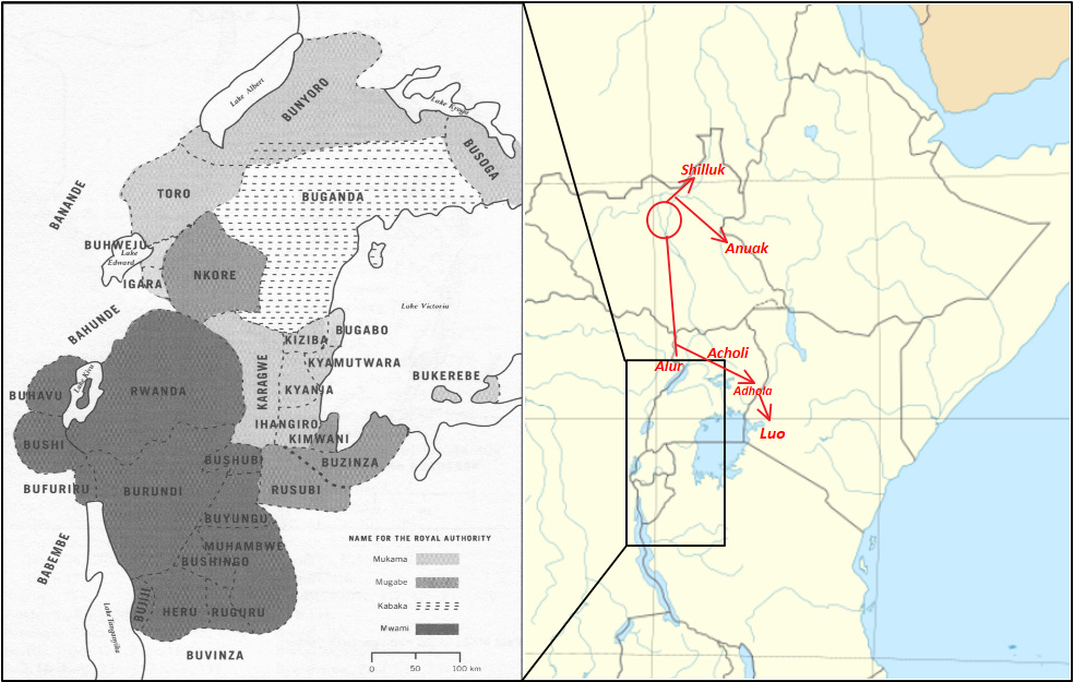
One group led by Nyipir moved westwards across the Nile, established a pattern of dominant lineages and chiefdoms over the preexisting Lendu-Okebo-Madi. Another group, under Labong’o, traveled southwards, invaded the kingdom of Bunyoro, and established its ruling Bito dynasty. From Pawir in Bunyoro, the Luo expanded across Acholi and Lango regions, and south-east to the kingdom of Busoga. The last group moved east beyond Mount Elgon, forming the ancestral populations of modern Padhola of Eastern Uganda and Dholuo of Western Kenya and northern Tanzania.12
The impact of these Luo expansions on the Inter-Lacustrine Bantu-speaking world has been the subject of several studies, for it was a process that occurred well within the period for which historical evidence is abundant
In most anthropological literature, the Western Nilotic-speaking groups are characterized as acephalous (stateless) societies of mobile herders, in contrast to the Interlacustrine Bantu-speaking groups, who are sedentary and formed several centralized kingdoms.
However, this generalization is complicated by the presence of various forms of social organization among the Luo-speakers and their transition from nomadic herders to sedentary farmers in different contexts.
The diverse forms of Luo social organisation examined here included: centralised Kingdoms (e.g., Shilluk and Bunyoro’s Bito dynasty); “segmentary states” famously identified by the anthropologist Southhall among the Alur; and chiefdoms headed by a Ruoths/Rwoths among the Ugandan Acholi and Kenyan Luo.13
According to the historian Roland Oliver:
By the fifteenth century there were no more broad ecological gaps occupied only by hunter gatherers and inviting settlement by food-producers equipped with cattle and hardy cereals. Successful migration by this time usually involved the conquest of existing states and some kind of subsequent accommodation whereby the conquerors became the rulers in the political systems of the conquered. Hence the Lwo, though politically acephalous in their own homelands, emerge in Bantu history as kings and nobles in systems built up by others. And very soon, much sooner than their Southern Nilotic predecessors [eg Kalenjins of Kenya], their migrations ran out of steam.14
The most significant cultural synthesis occurred in the kingdom of Bunyoro, and the semi-legendary “empire” of Kitara.
Traditional histories of Bunyoro’s Babito dynasty were first recorded (and infamously conflated with the Hamitic myth) by John Speke in his 1855 visit to the court of King Kamurasi (r. 1852-69).
They were later described in greater detail by educated court historians like Nyakatura, who removed the Hamitic myth from Bunyoro’s dynastic history very early on. He detailed the divine origins of the empire, how it was inherited from the godly Batembuzi dynasty by the semi-divine Bacwezi, who then transferred power to the immigrant Luo-Babito.15
The historian Renée Tantala argues that pre-colonial Babito synthesized many traditions, emphasizing their position as heirs to an ancient empire, in order to increase their legitimacy at home and abroad. King Kamurasi asserted to Speke that he was ‘the father of all to the kings’ of the region, and Baker was assured soon afterwards that Bunyoro’s proper name was Kitara. In 1875, another European visitor heard the king of Bunyoro, two rebel Nyoro princes, and the king of Buganda each claim to be the only true descendants of the princes of Kitara.16
According to the historian Shane Doyle:
This regional scramble to assert direct links to a state called Kitara does make it likely that some such kingdom did once exist. Accepting the probable reality of Kitara, however, does not require belief in the Bacwezi as a dynasty, the territorial extent claimed for Kitara, nor even the images of a centralized, homogenous administration conjured up by Europeans’ fixation with the notion of an ancient empire. Kitara almost certainly would have been held together more by ideological power, trading links, personal ties and clan alliances than by systematized, bureaucratized government.
Kingship is an ancient feature of this region, and almost certainly predated the arrival of the Babito clan from the Luo-speaking areas of Bukedi or Lango, which probably occurred around the late 16th century. Nyakatura refers to a hereditary official who was named after the interpreter of the first Bito king, who did not know the presumably Bantu language of Kitara. Although many Bito personal names are Luo, Bunyoro’s political terminology features only two words of Luo extraction, ekikali and dyangi. The predominance of Bantu political terms strongly suggests that kingship preceded Bito rule.17
Besides the Bito, the kingdom of Bunyoro interacted with other Luo-speaking groups, most notably the Palwo/Alur to its north, some of whom intermarried with the ruling lineage, and harboured rival candidates such as Ruyonga. The Bunyoro king Kabarega (r. 1870-1899) also traded ivory, copper, and guns with the Acholi chiefdoms to the north.18
When the Turco-Egyptian expeditions were sent against the Acholi chiefs in 1886 for refusing to pay their tax, Kabarega supplied the chiefs with soldiers and guns to support revolts north of the Nile and west of Lake Albert. The Acholi, alongside the Alur and Langi, later formed the core of the trained army of riflemen formed by Kabarega in the 1880s that would fight the British colonial forces for about two decades.19
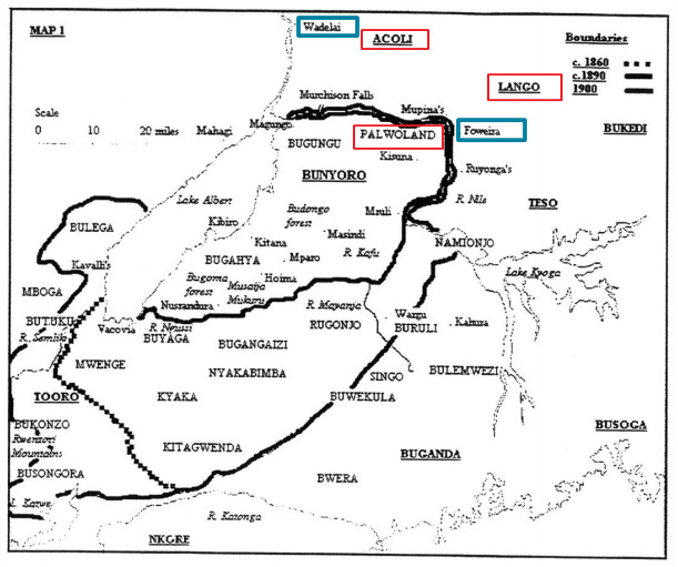
19th-century Bunyoro showing the neighbouring Luo-speaking societies (highlighted in red), and the Turco-Egyptian stations (highlighted in blue). Based on a Map by Shane Doyle.
The concept of the segmentary state was developed by the anthropologist Aidan Southall in 1956 in order to characterize and explain the political system he encountered among the Alur during the late colonial period.
He defined the segmentary state as “one in which the spheres of ritual suzerainty and political sovereignty do not coincide. The former extends widely towards a flexible, changing periphery. The latter is confined to the central, core domain.” In the case of Alur societies, they recognized a ruling clan known as the Atyak, who achieved domination without the advantage or application of force, but rather from ‘the impact of belief in more potent supernatural power.’20
Southall positioned his concept of the ‘segmentary state’ between what the anthropologist Evans-Pritchard (1940) classified as centralized “state systems” and acephalous or “segmentary lineage systems”. Southall subsequently applied the segmentary state model elsewhere, including to the ancient kingdom of Kitara (not Bunyoro), the Yoruba, Anglo-Saxon England, and 11th-century France.21
The segmentary model was largely a product of its time, developed during a period when historical research on African societies remained limited. As archaeological and historiographical evidence has expanded, the model has come under sustained criticism, particularly in the very regions where it was first formulated.
The archaeologist Peter Robertshaw argues that Kitara was not a segmentary state, nor was the political system of the Alur. His examination of archaeological data from the late Iron Age earthworks, settlements, and hilltop shrine sites in Bunyoro, dated to between the 14th and 16th centuries, suggests competing nodes of instrumental and “creative” authority that resemble the state structures of 19th-century Bunyoro.
In 19th century Bunyoro, kingship was the center of secular power, from which political authority was delegated in the form of grants of estates to great chiefs and lesser chiefs. The King, however, was not a divine ruler nor an intermediary with spiritual powers. This role fell to the priests of the Cwezi shrines scattered across the kingdom, who represented competing yet ultimately subordinate centers of power.22
According to Robertshaw, this indicates that centralized authority in 19th-century Bunyoro was circumscribed in various ways, even under the powerful monarch, Kabarega, who brought the breakaway Toro kingdom back under Nyoro control by force of arms.
It should also be noted that the Alur were not entirely independent in the 19th century, since, as Southall acknowledges, they recognized the suzerainty of Kabarega as late as 1879.23
This was before the Turco-Egyptian forces of Emin Pasha, and later colonisation by the Belgians and British profoundly altered the region’s political organization. Southall was therefore describing a situation largely as it appeared in the 20th century, long after these changes, rather than the earlier historical configuration of Alur political authority.
At the time of Emin Pasha (1885-9), there were originally three large Alur chiefdoms (ultimately under Bunyoro’s suzerainty), but these had fragmented due to political upheavals associated with the Turco-Egyptian expansion.
Emin notes that the authority of the Alur rulers was greater than among the neighbouring Acholi chiefdoms, and their administrative systems were more formalised. Nevertheless, similar forms of tribute, taxation, courts, and inheritance existed in both Luo-speaking groups.24
It should also be noted that Emin was describing an Acholi society after it was devastated by Turco-Egyptian expeditions, of which he was partially responsible.
He acknowledged in his private journal that the invasions “inflicted quite unnecessary cruelty… When I came here 11 years ago, Acholi land was well populated, rich in corn, honey, etc., and its inhabitants friendly and peaceful. Every station has indulged in plunder, all my exhortations have been disregarded.”25
Similarly, the pioneering anthropological work of Evans-Pritchard among the Luo-speaking Anuak (South Sudan/Ethiopia) and the Luo of Kenya during the 1930s and 40s was also criticized by later scholars for downplaying the authority of rulers in these societies during the pre-colonial period.
They argue that his work ‘contradicted prevailing interpretations of their political significance, with little regard for the value of historical documentation and ethnographic factors to the contrary’.26
Among the Luo of Kenya, Evans-Pritchard’s opinion was that there were no chiefs among the Luo, and claims that the Rwot ‘was an influential person, but no more’.27 This contradicts both earlier accounts and later historiographical research.
The colonial administrator Geoffrey Northcote, considered chieftainship as key to Luo social organization: ‘Each chief ’, he wrote, ‘subdivides his territory, placing each portion under a sub-chief.’ The missionary Walter E. Owen also wrote that ‘in the tribal organization, the central figure around which all the tribal life revolves, and who embodies the tribal loyalties and welfare, is the ruoth or tribal (or clan) head’.
Their views are shared with the Historian Bethwell Ogot, who wrote that ‘each oganda [tribe] was an independent economic, political and ritual unit. Each had its own Ruoth (chief). The Ruoth was the jural-political leader of the “tribe”.’ The oganda itself, of which the Luo in Kenya had around thirteen, was composed of groupings of patrilineal clans or large lineages, which in turn were subdivided into smaller patrilineal segments.28
Arguably, what muddied the waters considerably in his interpretation was the extent of change and disruption caused to Luo society as a result of nearly forty years of colonial rule (since 1895), and how much it could represent the pre-colonial forms of social organization.
Like in Bunyoro, archaeological research can provide some clues regarding the organisation of these societies.
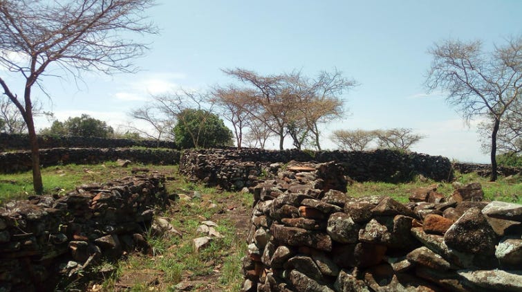
While archaeological studies have been relatively limited in most of the Luo-speaking regions examined in this essay, a number of them have been undertaken across numerous stone-walled settlements in South-Western Kenya. This research provides additional data to corroborate some of the historical traditions.
Approximately 138 stone settlements containing 520 structures have been surveyed across the region, along with an additional 500 walled settlements/“forts” that feature free-standing earthen walls and moats.
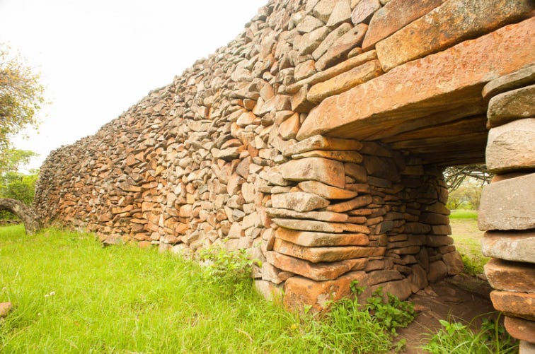
The largest and most complex of the stone ruins is the site of Thimlich Ohinga, where the main monument consists of an outer compound wall, 115 m in diameter and 2.5-3.5 m high. Between the enclosures are passageways and corridors lined with low stone walls that designate residential spaces, cooking areas with hearths, kraals, and industrial areas for iron smelting, including furnaces and iron tools.
[see my essay on The Stone Ruins of Thimlich Ohinga ]
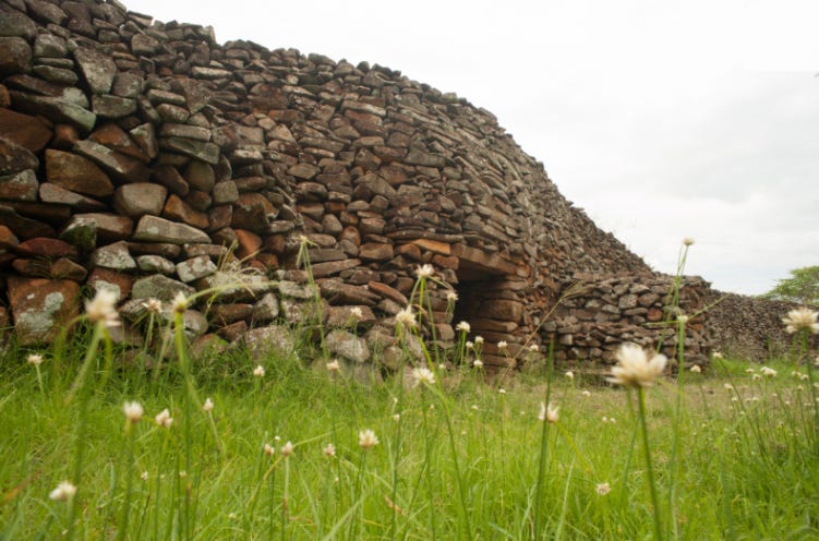
Ruins of Thimlich Ohinga and a Map showing the distribution of stone-walled settlements in western Kenya.
Historical traditions of the societies near Thimlich indicate that the region was successively occupied by different groups belonging to both the Bantu and Nilotic speakers. Most of the pottery found in excavations at the main enclosure was decorated with a knotted cord-roulette, with motifs similar to those used in the modern pottery traditions of the Nilotic-speaking Luo. Charcoal samples from the sites yielded a date range of 1650 to 1900 CE.29
The archaeologists Onjala and Kamaru suggest that 17th-century Thimlich was a village complex with a single leadership, and that the site became a center from which territorial conquests into neighboring areas were conducted. It likely developed as an administrative center where leadership consultations and the organisation of labour were undertaken.
The monuments suggest the emergence of a more complex society where labour was highly organized to meet the demands for gathering and transporting the raw material, and control of the construction efforts. The political and cultural importance of the site ensured its occupation until its eventual abandonment during the upheavals of the early colonial period.30
In the western Interlacustrine region, the Luo had been acculturated into the pre-existing and more dominant Bantu-speaking kingdoms of Bunyoro and Busoga. But in South Western Kenya, the pre-existing societies were not as socially stratified. Lineage groups (clans) initially served as the main social institutions for mediating exchanges and conflicts, as well as integrating incoming groups.
Both the Luo and Bantu-speaking societies in this region used the clan as a device for social integration, some of which became socially stratified to form chiefdoms by the 17th and 18th centuries. Only one of these chiefdoms, Wanga, was primarily Bantu-speaking. The important early Luo-ruled chiefdom in those centuries was nearby Alego. It has been suggested that the intensity of social interaction in this region created pressures and conflicts that could best be resolved by the integrative factor of chiefship.31
As in most regions described in this essay, the Luo-speaking groups transitioned from a mobile pastoral lifestyle into a strong sedentary community, practising a mixed economy of agro-pastoralism.
External pressure from the neighbouring state of Busoga to the west and the larger kingdom of Buganda may have also influenced the formation of nucleated settlements and the construction of defensive architecture across the region.
In 17th century Busoga, several polities in its north and east developed around the dominant, albeit temporary, positions of Luo lineages, mostly notably the Owiny Karuoth, who were acculturated into Bantu-speaking Soga society. Institutions became increasingly centralised as appoitive and hereditary offices emerged in the 18th to 19th centuries, especially in the Bantu-speaking south. The kingdom became more socially stratified, influenced by the expansion of Buganda’s hegemony.32
By the late 19th century, the armies of Buganda’s expansionist king Mutesa (r. 1856-84) were campaigning as far east as Western Kenya, mostly using its navy against some of the walled settlements in the region. These campaigns may have restricted the territorial expansion of the nascent polities.
The explorer Joseph Thomson in 1883-5 writes: “About Massala we observed numerous deserted villages, and on inquiry we learned that they were the result of raids of Mtese’s warriors, who were in the habit of making descents on the Samia coast. The neighbouring state of Akola to the west had lately fallen a victim to that potentate’s imperial policy, and his name was held in great terror. We ourselves on more than one occasion were mistaken for Waganda, and the alarm and war-cry spread accordingly.”33
“War canoe of the Wavuma advancing to battle.” ca. 1890. by D. M. Kelsey. Illustration based on H.M.Stanely’s drawing of the war canoes used in the battle between Buganda and Buvuma.
Thomson also provides the first description of the walled towns of “Kavirondo” in western Kenya. Later travellers and colonial administrators often distinguished between the “Nilotic Kavirondo” (later known as the Luo) and the “Bantu Kavirondo” (later known as the Luhya). The differences in the settlement patterns of the two groups were, however, not particularly pronounced, and it’s clear that such walled constructions were found in many different groups.
In his description of the Luhya, Thomson mentions “chiefs” ruling over several walled settlements like Kwa-Sundu, Massala, and Masawa, with large populations, cultivated farms, and the capacity to absorb a large section of Maasai refugees. The abundance of trade goods at Kwa-Sundu, its importance relative to other walled settlements, and its chief’s alliance with Swahili traders who attacked Masawa, equate it to other towns in the East African interior like Tabora and Ujiji that played a central role in the emergence of states among the Nyamwezi of Tanzania.34
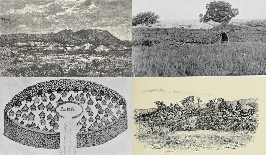
Various walled settlements in S.W Kenya. (clockwise) The walled village of Kabaras, Kavirondo. illustration by Joseph Thompson, ca. 1883. A walled village in Kavirondo, north of Nzoia River. Image by H. Johnston, 1902. A Kach village, image by G. H. Gorges, 1899. Doorway in the wall of a Kavirondo village. Image by John Bland-Sutton, 1911.
The first description of Luo political structures in this region comes from Charles Hobley, who was writing in 1896, long after the upheavals mentioned above.
He notes the presence of “chiefs”, whose authority over their subjects was, however, relatively limited: “they are assertively independent, and to such a degree that it is but rarely one finds a chief who has any real control over his people.” The office was mostly hereditary, and its function was concerned with organising defense against the attacks of the neighbouring Nandi and Masaai.35
A description of walled settlements of the Luo comes from G.H Gorge, who visited the south-east coast of Winam Gulf in 1899. He observed that settlements of the Kach (NyaKach, a section of Luo-speakers) were “surrounded by walls built of stone and mud” to defend them against attacks by the Kosova [Kissi] and the people of South Kavirondo from the north.36
Sir Harry Johnston (1902), who uses the now more common term of “Ja-luo”, mentions that they used to build stone and earthen walls “in imitation of the Bantu Kavirondo to the north. But this is a custom which has now died out.”37
Charles Eliot (1905) noted that while the northern settlements continued to build earthen walls, the “Ja-Luo” now surrounded theirs with a “thick-set hedge of euphorbias and aloes.”38 Sir John Bland-Sutton (1911) attributed the earthen and stone walls of the Kavirondo to the threat posed by the Nandi.39
C.H. Stigand also mentions stone walls among the Nilotic (but non-Luo speaking) Kisii, whose settlements were fortified by a high wall of rubble or earth, surrounded by a ditch, and were “more formidable than the low Kavirondo earthworks.” 40
The defensive function of both stone and earthen fortifications was widely noted by early travellers to the region. These structures later played a significant role in resisting the British colonial invasion of 1895.
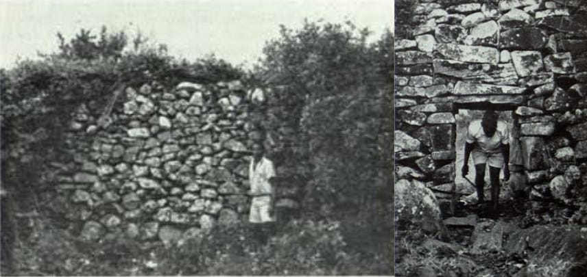
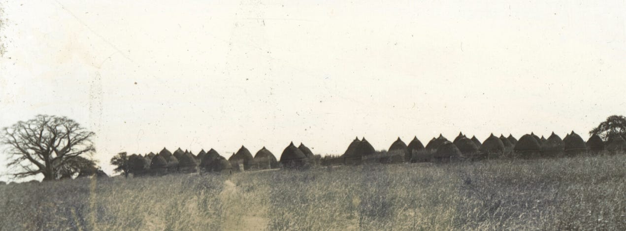
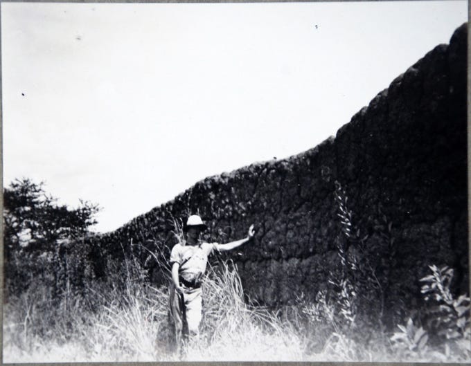
Minyere Hill, Part of Wall of Boma No.3, interior. Minyere Hill, Boma No. 3, interior of Main Entrance. Images and Captions by N. Chittick, 1965.41
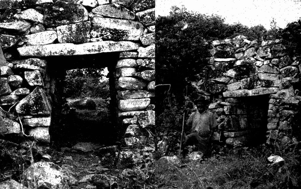
Stone structure on Minyere Hill, Kanyamkago, South Nyanza. Main entrance to Boma. Image by N. Chittick, 1965.
The Turco-Egyptian irruption and colonial rule in 19th-century Luo History.
The Luo-speaking world experienced profound political upheaval in the second half of the 19th century, as a series of foreign armies and merchant groups entered the region, conducting extensive raids before its eventual occupation by colonial forces.
The northern areas were particularly affected by these disruptions. The Shilluk were able for some time to hold the Funj at bay, until the Funj kingdom itself was invaded and absorbed by Turco-Egyptian forces. Initially, Turkish and Arab incursions were limited in scale, largely consisting of cattle raids and slave-taking expeditions, with only a single recorded expedition penetrating Shilluk territory in 1830.42
From the 1840s onward, however, the activities of Turco-Egyptian government (Turkiyya) and commercial agents in the southern regions became increasingly predatory. They set up zaribas (fortified residences) from which they raided their southern peripheries for slaves. The southerners often resisted the presence of these foreign traders in their land, producing a persistent and destructive cycle of conflict between the two.
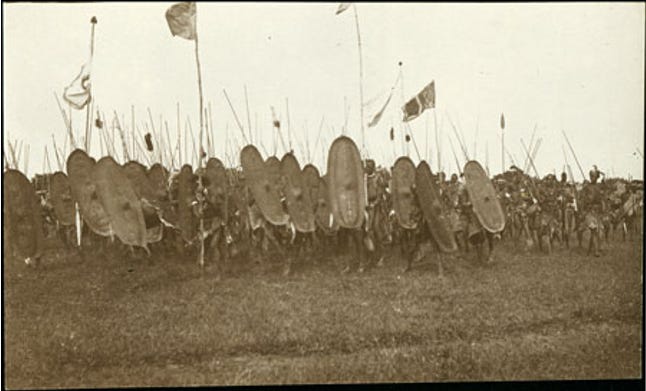
A large group of Shilluk men in a line brandishing hide shields and spears at a dance gathering. ca. 1928. Pitt Rivers Museum
In 1860, Shilluk’s King Kwatker expelled many Arab traders from his kingdom. The latter, under the leadership of Muhammad al-Khäyr, responded by sacking the royal capital, Fashoda. Contemporary visitors in 1862 wrote of the aftermath of this devastation, describing how ‘the once-powerful Shillooks have been scattered far and wide’. The Shilluk counter-attacked in 1863, killing Muhammad al-Khäyr.
In late 1863, the Khedive Ismail of Egypt (r. 1863-79) established a garrison in Shilluk country as part of his ambitious southern expansion up the Nile. The relationship between Shilluk and the Turco-Egyptian authorities deteriorated rapidly. The administration levied a heavy tribute, compelling the Shilluk to rebel by attacking garrisons at Kaka and Fashoda. Turco-Egyptian reinforcements crushed the Shilluk armies in 1876, and turned the kingdom into a province until their expulsion by the Mahdists in 1881.43
The Khedive extended his influence south into Acholi territory. Here, the Turco-Egyptian presence was primarily seen as an occupation force protecting their traders, who were not inclined to involve the Acholi in trade except as menials, porters, and interpreters. Unlike the situation among the previously “stateless” Nyamwezi of Tanzania, where external trade encouraged state-building, the foreign presence was almost entirely destructive.
In response, some Acholi states migrated away from areas of alien concentration, and others, such as Patiko, fragmented into insignificant political units. The exception was the Acholi state of Padibe, whose Rwot (king) Ogwok expanded its borders, developed a new bureaucratic structure, set up new industries such as weaving, began the adoption of Arab dress styles, and organized a standing army.44
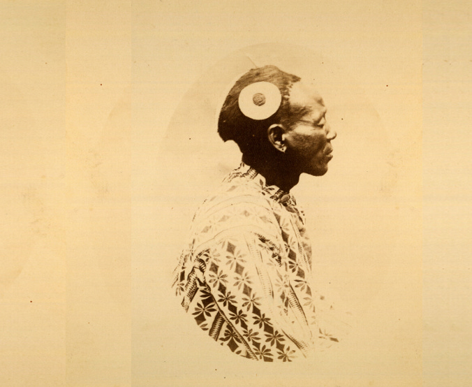
A vignette upper body profile portrait of an Acholi chief, identified as Aguen, wearing a patterned shirt with a disk hair ornament. January 1879, photo by Richard Buchta, Acholi, Uganda. Pitt Rivers Museum.
The Turkiyya collapsed in 1881-5 under the Mahdist revolt, which quickly took over much of Sudan but failed to hold any of the southernmost regions for long. Their influence was ultimately reduced to the single isolated station at Bor. In September 1898, the Mahdist state was defeated by the British colonial armies, who would by 1899, occupy Shilluk and Acholiland. The last independent Shilluk monarch was deposed in 1903.45
In the east, the Anuak territory wasn’t colonised until two decades later
The Anuak, like most Luo-speakers, had also transitioned to sedentary farming. They lived in nucleated settlements under a headman who recognized the authority of the nobility, which in turn belonged to a royal clan headed by a King. However, the Anuak king’s authority was relatively limited. Succession was marked by fierce competition between nobles for possession of the royal emblems. They were thus vulnerable to expeditions of both the Ethiopians and Nuer.46
By 1911, the Anuak acquired firearms from Ethiopia, allowing them to shift the balance of power against the Nuer. At least three kings, Akwey, Oodial, and Uliimi, were known at the time of the British arrival in 1912.47 The border between British Sudan and Ethiopia cut through Anuak territory, splitting the two kingdoms of Akwey and Oodial on either side of the border. Rival candidates often fled to Ethiopia to recruit followers, prompting the Colonial administration to forcefully install one ruler but stripping him of most authority, and paying him a salary as a civil servant.48
Riverine settlement of the Baro Anuak, ca. 1935, South Sudan. Pitt Rivers Museum.
In western Kenya, the Bukusu “forts” of the predominantly Luhya (Kitosh) communities became the sites of fierce anti-colonial resistance in 1895 at Lumboka Fort (near modern Bungoma town) and Chetambe (near modern Webuye town). After their defeat, the colonial officers insisted on the demolition of the Bukusu forts, although many walled settlements were still occupied a decade later.
Photographs from the 1910s and 1930s nevertheless show that many of these settlements had been abandoned, their moats were overgrown with vegetation, and the clay walls were gradually melting away in the humid climate. It was during this time that the walled settlements of the Luo in southern Nyanza were also being abandoned.49
Remains of a walled settlement in Kitosh, northern Kavirondo. ca. 1910-1920. Museum of Archaeology and Anthropology, Liverpool.
Conclusion: Colonial reorganisation and colonial Anthropology.
After the British formally established colonial control over western Kenya in the early twentieth century, they undertook a comprehensive reorganisation of local administration.
Each region had a government-appointed chief over a specific territory, but was ultimately subordinate to the district officer. These titled figures, created by the British in 1902, were not like the pre-colonial rulers, but were essentially civil servants who received a monthly salary but were stripped of all traditional authority.50
By the time Evans-Pritchard was hired by British colonial administrators to intervene in the succession disputes of Anuak and (briefly) the Kenyan Luo, both societies had undergone significant internal changes in their political organisation that aren’t fully addressed in his anthropological study.
Similarly, Aidan Southall’s description of Alur society in the late colonial period largely reflected more recent forms of social organisation shaped by the exigencies of colonial administration.
Taken together, the work of these two highly influential scholars, which is still widely cited by social scientists today, is largely detached from the pre-colonial contexts to which their models of political organisation are often retrospectively applied.
The historical evidence of Luo migration and state formation reveals the complexity and variability of social organisation in pre-colonial Africa, as well as the profound impact of external forces during the 19th century that reshaped the continent’s political landscape into the forms we recognise today.
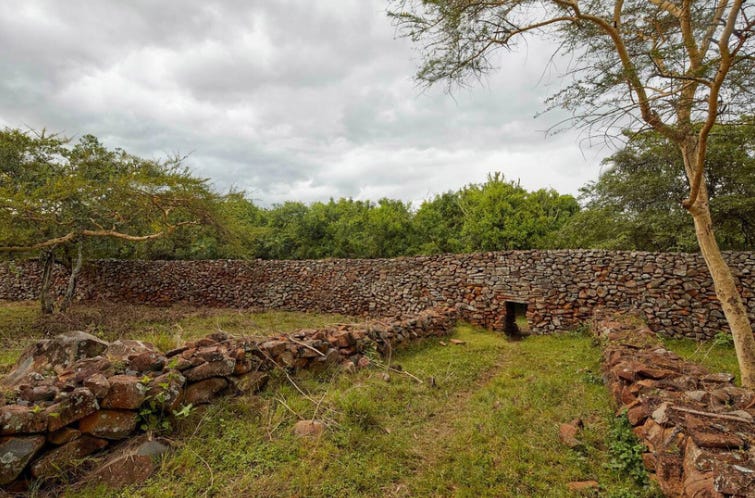
Thimlich Ohinga, Western Kenya.
Among the most significant beneficiaries of the economic growth and political changes in 19th-century Africa were the Chokwe of Central Africa, who went from a relatively obscure group on the margins of the great kingdoms of the Savannah to becoming the region’s most dynamic economic and military forces.
The history of the Chokwe Revolution, Trade, and Artworks is the subject of my latest Patreon article. Please subscribe to read more about it here:
Kingdoms of the Sudan by R.S. O’Fahey and J. L. Spaulding, pg 24
The Noun Morphology of Western Nilotic By Anne Storch
The Noun Morphology of Western Nilotic By Anne Storch, pg 17-28
Who Are the Luo? Oral Tradition and Disciplinary Practices in Anthropology and History by John R. Campbell, pg. 80-83. Siaya: The Historical Anthropology of an African Landscape By David William Cohen, E. S. Atieno Odhiambo, Pg 16-18
*Ogot acknowledges that the Hamitic hypothesis and the use of glotto-chronology in historical reconstruction were problematic. see; UNESCO General History of Africa Vol 4, pg 505, n.23. Reintroducing Man Into the African World by Bethwell A. Ogot, pg 61
History of the Southern Luo: Migration and Settlement By Bethwell A. Ogot, pg. 44-46
Islamic archaeology in the Sudan by Intisar Elzein
The Funj: A Reconsideration by Jay Spaulding
The Shilluk Reth, Early King or Head of State?An Inter-Nilotic Exploration by Simon Simonse. The Shilluk people, their language and folklore, by Diedrich Westermann
Kingdoms of the Sudan by R.S. O’Fahey and J. L. Spaulding, pg 61
Kingdoms of the Sudan by R.S. O’Fahey and J. L. Spaulding, pg pg 62-64
The Shilluk people, their language and folklore, by Diedrich Westermann, pg Lii-Lv.
History of the Southern Luo: Migration and Settlement by Bethwell A. Ogot, pg 46-47
Reintroducing Man Into the African World by Bethwell A. Ogot, pg 65-67
The Nilotic Contribution to Bantu Africa By Roland Oliver, 441
Anatomy of an African Kingdom: A History of Bunyoro-Kitara By John W. Nyakatura
Crisis & Decline in Bunyoro: Population & Environment in Western Uganda 1860-1955 by Shane Declan Doyle, pg 12-13
Crisis & Decline in Bunyoro: Population & Environment in Western Uganda 1860-1955 by Shane Declan Doyle, pg 14
Crisis & Decline in Bunyoro: Population & Environment in Western Uganda 1860-1955 by Shane Declan Doyle, pg 43-44.
Crisis & Decline in Bunyoro: Population & Environment in Western Uganda 1860-1955 by Shane Declan Doyle, pg 43-44, 50, 56
The Segmentary State in Africa and Asia by Aidan Southall, pg 52-58. Alur society: A study in processes and types of domination by A. W Southall.
Technology, Tradition and the State in Africa, by Jack Goody, pg 9-10
Beyond the Segmentary State: Creative and Instrumental Power in Western Uganda, By Peter Robertshaw
Alur Society: A Study in Processes and Types of Domination by Aidan Southall, pg 280-282
Mit Emin Pascha ins Herz von Afrika (With Emin Pasha in the Heart of Africa), Berlin, 1894, pg 492-529.
“The diaries of Emin Pasha — extracts IX’, edited by J. Gray, Uganda Journal, 29, 1 (Mar. 1965), pg. 75-82.
The Anthropological Lens: Rethinking E. E. Evans-Pritchard By Christopher A. Morton, pg 150-155. Evans-Pritchard and the Prophets: Comments on an Ethnographic Enigma by W. Arens.
Luo Tribes and Clans by Evans-Pritchard, pg 28
The Anthropological Lens: Rethinking E. E. Evans-Pritchard By Christopher A. Morton, pg 200
Thimlich Ohingini by Simiyu Wandibba pg 134. Traditional conservation practices in Africa by ICCROM pg 99. Archaeological fauna from Thimlich Ohinga Cultural Landscape, South Western Kenya by C. Ogola et al.
Traditional conservation practices in Africa by ICCROM pg 100-101, Southwestern Kenya during the second millennium AD: Archaeology, environment, and socio-cultural change by IO Onjala pg 112-113
The Cambridge History of Africa, Volume 4, pg 482-485
The Political Transformation of Northern Busoga, 1600-1900 (Transformation politique du Busoga septentrional, 1600-1900, by David W. Cohen. Siaya: The Historical Anthropology of an African Landscape By David William Cohen, E. S. Atieno Odhiambo, pg 20-21
Through Masai land by Joseph Thomson, published by Sampson Low, 1887, pg 296
Through Masai land by Joseph Thomson, published by Sampson Low, 1887, pg 283-298
Eastern Uganda: an ethnological survey by C. W Hobley, History of the Southern Luo: Migration and Settlement By Bethwell A. Ogot, pg 236-239
A Journey from Lake Naivasha to the Victoria Nyanza by G.H. Gorge
The Uganda Protectorate (1902) by Sir Harry Johnston, pg. 780
The East Africa Protectorate by Sir Charles Eliot, pg 148
Man and Beast in Eastern Ethiopia: From Observations Made in British East Africa, Uganda, and the Sudan by John Bland-Sutton p 140
The land of Zinj: Being an account of British East Africa, its ancient history and present inhabitants by C.H Stigand, pg 298)
“A Note on Stone-Built Enclosures in South Nyanza, Kenya.” by Neville Chittick, in ‘Man: A Monthly Record Of Anthropological Science Vol.65 (articles 1-279)’ by The Royal Anthropological Institute
Cambridge History of Africa, Vol. V, pg 33
UNESCO General History of Africa Vol VI, pg 364-367. The Shilluk people, their language and folklore, by Diedrich Westermann, pg Lviii. The Formation of the Sudanese Mahdist State: Ceremony and Symbols of Authority: 1882-1898 By Kim Searcy, pg 33
Cambridge History of Africa, Vol. V, pg 312-313.
Cambridge History of Africa, Vol. VI pg 637-638. The Shilluk people, their language and folklore, by Diedrich Westermann, pg Lix-Lx.
Anywaa: The Luo of Western Ethiopia By Jekap Omod. Natives and outsiders: the historical experience of the Anywaa of western Ethiopia by Kurimoto Eisei, pg 11-12.
Sobat and Pibor District. Kingship Amongst the Anuak. in ‘Sudan Notes and Records, Vol. 4, No. 3 (1921)’ pg. 162-164. Reports on the Finance, Administration, and Condition of the Sudan Volume 2, published by F. Nimr, 1913, pg 12-13. Twixt Sirdar and Emperor: The Anuak in Ethio-Sudanese Relations 1902-1935 by Bahru Zewde
The Anthropological Lens: Rethinking E. E. Evans-Pritchard By Christopher A. Morton, pg 155. Policing the Empire : Government, Authority, and Control, 1830-1940, edited by David Killingray, David Anderson, Pg 163-164)
Two Accounts of the Chetambe War of 1895 by R. T. K. Scully pg 484-490. An Outline History of Babukusu of Western Kenya by FE Makila pg 38
The Anthropological Lens : Rethinking E. E. Evans-Pritchard By Christopher A. Morton pg 200-201
Thank you, sir, for this article. It illuminates many aspects of the Luo peoples of western Kenya, in which I have a personal interest.
Incredibly detailed and impeccably referenced.
So were the Funj Nubians? Or does nobody know who they really were? And doesn't anybody find it troubling how their heritage and presence was quickly erased, and how that relates to racial cleansing campaigns in modern day Sudan?
Lastly, I believe the Egyptians went on cattle raids and *slave raids*, not "slave-taking expeditions".