The stone ruins of Bokoni: egalitarian systems and agricultural technology in pre-colonial South Africa. (16th-19th century)
challenging conventional narratives on pre-colonial Africa's social order and agricultural practices.
The ruins of Bokoni in South Africa are some of the most spectacular remains of pre-colonial agricultural societies on the African continent. Extending over an area of 10,000 square kilometers are circular mazes of stone-built homesteads and towns linked by walled roads that are interspersed among spreads of agricultural terraces traversing the escarpments of Mpumalanga.
While this dramatic landscape has become a magnet for exotic pseudohistorical theories ranging from ancient aliens to foreign builders, Its construction and settlement by various local African groups has been known since the work of professional archeologists in the 1930s who dated its establishment to the late 16th/early 17th century. Bokoni’s relatively unique form of political organization and agricultural specialization greatly transformed conventional understanding of African history.
This article explores the history of the Bokoni settlements over the past 400 years, including an overview of their political organization and intensive agricultural practices.
Map showing the Location of the Bokoni area in Mpumalanga, South Africa
Support AfricanHistoryExtra by becoming a member of our Patreon community, subscribe here to read more about African history, download free books, and keep this newsletter free for all:
A brief history of Southern Africa until the early settlement at Bokoni in the 16th/17th century
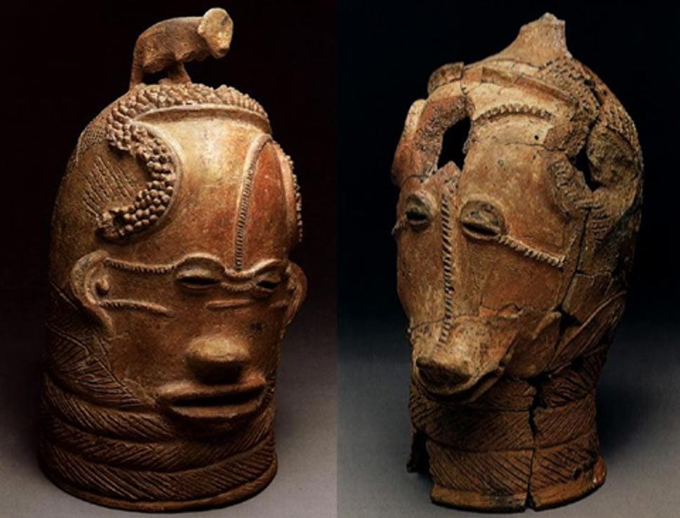
In the period preceding the establishment of Bokoni, the province of Mpumalanga (located in the north-east of modern South Africa) was settled by various agro-pastoral and foraging communities, the former of whom were part of the wider population drift of Bantu-speaking groups that arrived in the region around the turn of the common era1. These groups gradually established various polities in the region, and are credited with producing the Lydenburg terracotta heads that are dated to the 5th century, and were found in the area that would (much) later become the Bokoni heartland2
Iziko South African Museum
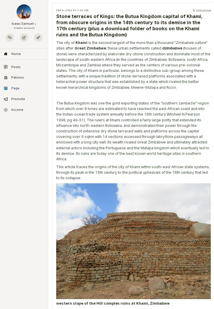
Larger, and more complex states emerged across the region of Mpumalanga by the late 16th to early 17th century around the time when Bokoni was flourishing, these included the neighboring states of Pedi and Ndunduza among others3. Contrary to its more centralized neighbors, Bokoni's political structures were likely characterized by competing nodes of power in which political and ritual paramountcy was exercised by dominant lineages over diverse populations. And like the heterarchical forms of political organization recently suggested for the better known kingdoms based at Great Zimbabwe and Khami4, there is little archeological evidence in the homestead complexes of Bokoni, for a sharp overarching hierarchy dividing elites and commoners.5
The Bokoni settlements weren't occupied simultaneously but in stages, with the southern sites constituting the earliest phases of settlement, which progressively moved northwards likely in response to external threats.6 The core settlement of Bokoni was occupied by heterogeneous groups of Sotho-Tswana and Nguni-speakers who were referred to as "Koni" (ie; ba-Koni 'people of koni'); an exonymous term used by their neighbors (especially the baPedi) to describe the people who they found living in the escarpments when the baPedi arrived after the baKoni in 1650. The term was later adopted by the inhabitants of Bokoni as a form of self-identification, along with the development of the Sekoni language.7 (archeologists use the term Bokoni for the ruined settlements and baKoni/ Koni for the people who built them)
The inhabitants of Bokoni were engaged in regional trade, and much of it was based on exchanging their surplus cereal and cattle products for iron goods and textiles in the regional trade networks, as well as ivory for the long-distance trade terminating at Delagoa Bay. Despite Iron's widespread use in Bokoni for making weapons as well as domestic and agricultural tools, there is limited evidence of its production within the settlement, and its likely to have been obtained through trade with the Pedi kingdom and other neighboring groups.8
The Bokoni settlement sequence from the late16th/early 17th-19th century9
Description of the settlement at Bokoni: Homesteads, Roads and Terraces.
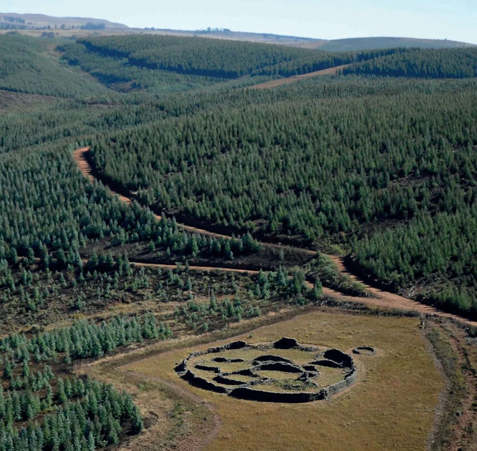
The architectural constructions of Bokoni comprise three main elements; the homestead complexes, the terraced fields and the road networks. The largest settlements such as Komati Gorge, Moxomatsi and Khutwaneng (see map above) are considered towns/capitals and they're primarily comprised of aggregations of homesteads marked by intensive residential terracing and road networks.10 The general layout took on the form of a circular structures beginning with a central cattle pen that was accessed using passages, and was inturn surrounded by clusters of homes and granaries divided into different domestic compartments accessed through separate passages leading into outside roads, that were all enclosed within a wall, and together constituted a homestead complex.11 The largest single complexes extend up to 5 km, they contain domestic units that range from large enclosures and compounds with well-developed roads and terraces to small enclosures of newly established homesteads.12
Large and complex interconnected homesteads
enclosure wall
Detail of a homestead complex and an illustration showing a plan of a complex homestead occupied by atleast a dozen homes, with walled passage between outer domestic area and inner livestock pens
The stone-walled roads of Bokoni were constructed between the homestead complexes to link other parts of the settlements, and they were also constructed in parallel lines down-slope, to move people and their livestock through the agricultural terraces on the slopes of the hill to the grazing and watering areas in the the valley.13 The roads were built according to the contours of the hill slope rather than cutting through underlying rock to follow a defined trajectory, and they served a wider range of functions including the delineation of livestock roads through cultivated areas, and the separation of cultivation from grazing areas.14
Homesteads with road junctions amid terraces at Rietvlei
Detail of settlements at rietvlei showing the partial outlines of roads connecting homesteads to a grazing area in the valley
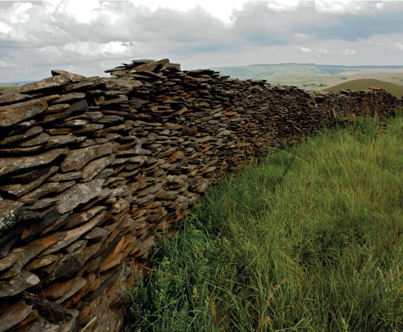
Most of the homestead complexes are surrounded by walled terraces of agricultural land that extended for several kilometers on the slopes of the hills. The terracing walls rise to a height of 2 meters, are built with undressed stone they often consist of two outer layers constructed using large rocks, and an inner layer comprised of small coursing of flat slabs of slate placed on top of one another in a single Line, while others are filled with small rocks.15
Terracing as a form of intensive agriculture, was the most distinctive feature of Bokoni's agro-pastoral economy. After selecting slopes with the most fertile soil, stone terraces were constructed in stages with rows of rocks set into the sloping ground until the accumulation of weight from rainwash and cultivation uphill necessitated further support. This significantly reduced soil erosion and increased the percolation of water through the soil, which, considering the additional fertility provided by the manure, greatly increased the agricultural yield needed to sustain Bokoni's fairly large population.16 While the terraces were likely built communally and incrementally over a long period of time without the need for a hierarchical organization of labour in a short period of time (associated with its more centralized neighbors), the rows of stones laid downslope through the terraces doubtlessly represent boundaries of individual plots of extended families and appear even in isolated homesteads.17
Four stages in the development of a substantial bokoni type of terrace
Bokoni terraces
Dense settlement near machadodorp with circular homes, interconnecting roads and terracing
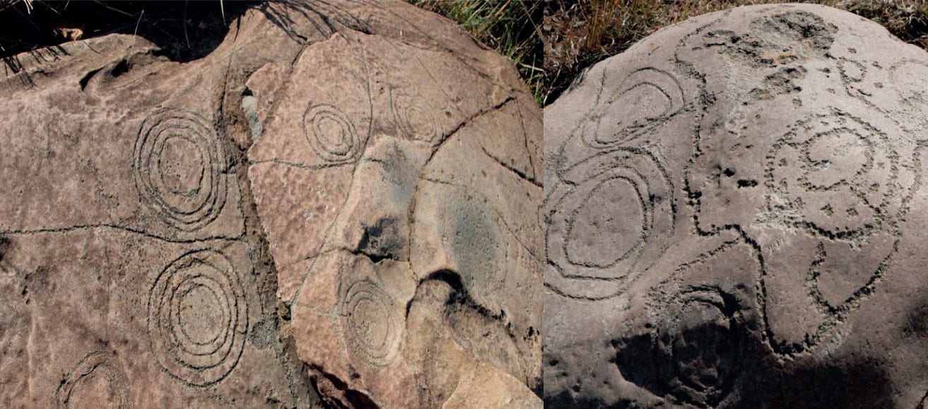
There's engraved and painted art on the rocks within Bokoni depicting the settlement patterns of the homestead complexes, terraces and roads, using a stylized design. The engravings, which weren't a reproduction of an actual settlement but show how it may have looked had it been built on the boulder.18
Rock engraving depicting the spatial arrangement of Bokoni homestead complexes as concentric circles, with roads connecting them
From zenith to decline and abandonment of Bokoni (18th century-1840)
Beginning in the mid-18th century, the Bakoni played a role in the expanding process of state centralization that was spreading across the region. The expansionist state of Pedi begun clashing with the northernmost Bokoni polities of Kgomane and Kutoane, which loosely came under Pedi political control in a tributary relationship, and as allies of competing Pedi factions, these Bokoni polities later became the base for Makopole, one of the princes of the Pedi king Thulare in 1810s.19
By the early 19th century, the formation of larger expansionist states to the south of Bokoni furthered altered the political landscape of southern Africa, and both the Pedi and Bokoni became causalities of these changes. While there's less information about the exact circumstances of Bokoni's abandonment, it likely coincided with the defeat of the Pedi by the armies of Ndwandwe sometime between 1823-1825, a few years before the latter's defeat by the Zulu in 182620. The inhabitants of Bokoni thereafter migrated to more fortified and safer areas while others were dispersed across the region eventually forming rump states, with one reoccupying Khutwaneng and battling with a reestablished Pedi state. By this time, the majority of the Bokoni settlements had been abandoned but the population was settled all across the immediate region eg at Kopa hill, Mafolofolo and Boomplats21 (see the settlement sequence map above in introduction), just prior to the arrival of the Boer 'trekkers' in the 1840s and the latter’s establishment of the Transvaal republic, a precursor to the British colonization of south Africa.22
political map of the eastern half of south africa between the late 18th and early 19th century, Bokoni is shown with a purple circle.
Bokoni’s place in African history; On heterachical states and intensive agriculture.
The 400 year old settlement at Bokoni was one of several examples of highly innovative pre-colonial African societies that utilized intensive agricultural techniques, greatly challenging the Eurocentric conception of African agriculture as “rudimentary” —A misconception that is particularly important in Southern Africa given the region's history with colonial settler farming predicated on the myth of "empty, underutilized land".
The heterarchical organization of Bokoni society with its extensive construction of road networks, terraces and densely settled towns following a defined pattern without the need for hierarchical political structures with kings and armies, is more evidence of the diverse nature of social structures in pre-colonial Africa, that is better known in ancient urban complex of Djenne-jano23, as well as in the monumental cities of Great Zimbabwe and Khami.24 And while this form of political organization was ultimately abandoned in the political revolutions of 19th century southern Africa, its accomplishments nevertheless undermine the conventional narratives of human progress from relatively egalitarian heterarchical systems to stratified and "despotic" centralized hierarchies of the post-neolithic era that became the foundation of modern states.25
Like Bokoni, the UNESCO world heritage site of Khami in Zimbabwe is a monumental construction built by a relatively egalitarian society, read about its history on Patreon
If you like this article, or would like to contribute to my African history website project; please support my writing via Paypal/Ko-fi
Kingdoms and Chiefdoms of Southeastern Africa by Elizabeth A. Eldredge pg 8
Forgotten World: The Stone-Walled Settlements of the Mpumalanga Escarpment by Peter Delius et.al pg 33-34)
Forgotten World: The Stone-Walled Settlements of the Mpumalanga Escarpment by Peter Delius et.al pg 43-47)
No Big Brother Here by Shadreck Chirikure, Tawanda Mukwende et. al pg 18-19
Bokoni: Old Structures, New Paradigms by P Delius, T. Maggs, A. Schoeman pg 406, 412)
Bokoni: Old Structures, New Paradigms by P Delius, T. Maggs, A. Schoeman pg 405)
Five Hundred Years Rediscovered: Southern African Precedents and Prospects pg 143-144
Bokoni: Old Structures, New Paradigms by P Delius, T. Maggs, A. Schoeman pg 411, Forgotten World: The Stone-Walled Settlements of the Mpumalanga Escarpment by Peter Delius pg 12-24)
many of the images (photos and maps) shown were taken from; Forgotten World: The Stone-Walled Settlements of the Mpumalanga Escarpment by Peter Delius
Precolonial agricultural terracing in Bokoni, South Africa by W. Maggs pg 3
Forgotten World: The Stone-Walled Settlements of the Mpumalanga Escarpment by Peter Delius pg 11-12, 55-80)
Bokoni: Old Structures, New Paradigms by P Delius, T. Maggs, A. Schoeman pg pg 402)
Forgotten World: The Stone-Walled Settlements of the Mpumalanga Escarpment by Peter Delius pg 13-14 Bokoni: Old Structures, New Paradigms by P Delius, T. Maggs, A. Schoeman pg 402)
Precolonial agricultural terracing in Bokoni, South Africa by W. Maggs pg 15
Bokoni: Old Structures, New Paradigms by P Delius, T. Maggs, A. Schoeman pg 401)
Precolonial agricultural terracing in Bokoni, South Africa by Mats Widgren pg 19-21
Precolonial agricultural terracing in Bokoni, South Africa by Mats Widgren pg 18, Bokoni: Old Structures, New Paradigms by P Delius, T. Maggs, A. Schoeman pg 409
Forgotten World: The Stone-Walled Settlements of the Mpumalanga Escarpment by Peter Delius pg 29-31)
Forgotten World: The Stone-Walled Settlements of the Mpumalanga Escarpment by Peter Delius pg 49-58, 155-157)
Five Hundred Years Rediscovered: Southern African Precedents and Prospects pg 150-151
Forgotten World: The Stone-Walled Settlements of the Mpumalanga Escarpment by Peter Delius pg 115-127
Bokoni: Old Structures, New Paradigms by P Delius, T. Maggs, A. Schoeman pg 406-407,)
Ancient Middle Niger: Urbanism and the Self-organizing Landscape By Roderick J. McIntosh
Great Zimbabwe: Reclaiming a ‘Confiscated’ Past by Shadreck Chirikure
The Dawn of Everything: A New History of Humanity by David Graeber and David Wengrow







Detailed as usual
Fascinating piece!