

The Congo River and its tributaries form one of Africa’s most extensive networks of navigable waterways.
Contrary to the misconception that Africa lacks navigable waterways, the Congo basin contains an estimated 8,400 kilometres (5,249 miles) of navigable rivers.
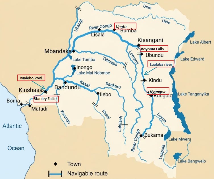
The Congo (Zaire) River itself is navigable for approximately 1,734 kilometres between the Malebo Pool and Kisangani (about the distance from Berlin to Madrid), its Kasai tributary is navigable for almost 1,000 kilometres, and the Sangha tributary for about 780 kilometres, among others.1
Historically, the river system provided corridors through the Central African rainforest along which populations migrated, settled, traded, and established complex societies, including some of Africa’s most distinctive forms of urbanism.
Although modern understandings of the Congo have been shaped by biased accounts of external observers, these same accounts document extensive traditions of boatbuilding, navigation, commercial competition, and naval warfare, that were products of indigenous institutional developments within Central African societies.
The strategic importance of these waterways, together with the region’s exploitable resources, would later turn the Congo basin into a major arena of colonial expansion and exploitation, whose effects continue to influence the region’s political landscape.
This article examines the history of navigation and society in the Congo basin, focusing on the economic and political interactions of riverine communities and states along its navigable waterways before the onset of colonial rule.
Map of the Congo river basin, highlighting some of the sites mentioned in this essay.
Support AfricanHistoryExtra by becoming a member of our Patreon community, subscribe here to read more about African history, download free books, and keep this newsletter free for all:
A brief background on the history of the Congo River
Thirty-two cataracts cut the course of the Congo River between the Atlantic Ocean and Malebo Pool, some 500 kilometers away. Between the first cataract, Ntamo, and the last one, Kasi, the river falls nearly 300 meters, creating the largest reserve of water power found anywhere in the world.
Below the cataracts, the river widens to form the Congo estuary, which cuts through the coastal plain for nearly 160 kilometers before meeting the sea. The waters of the estuary are calm, and they are navigable to oceangoing ships.
Above the cataracts and Malebo Pool, the river is navigable to Boyoma Falls near Kisangani, over 1,700 kilometers upstream. It flows lazily through the tropical rainforest, receiving a network of tributaries from the surrounding highlands.2
For nearly four centuries, the cataracts near the coast stymied repeated attempts by Europeans to reach the interior of Central Africa.
In 1485, the Portuguese captain Diogo Cao tried to sail his caravel upstream but was turned back by the cataracts.
In the 17th century, two expeditions by Catholic missionaries based in the Kongo kingdom succeeded in reaching the Malebo Pool via an overland route, but they were unable to go beyond it to explore the upper river.
In the early 19th century, the Tuckey expedition, sponsored by the British, ended in disaster, costing the lives of nearly half the party and failing to get even close to the Pool.3
The pool was finally crossed in 1877 by the Welsh-American explorer Henry Morton Stanley, who traveled not from the Atlantic coast but from the Indian Ocean, thousands of kilometers to the east.
He later returned for a second visit in 1879-1884 to found a colonial station at Kisangani, and again in 1887-1889 to rescue Emin Pasha. The first and third of these journeys are shown below.
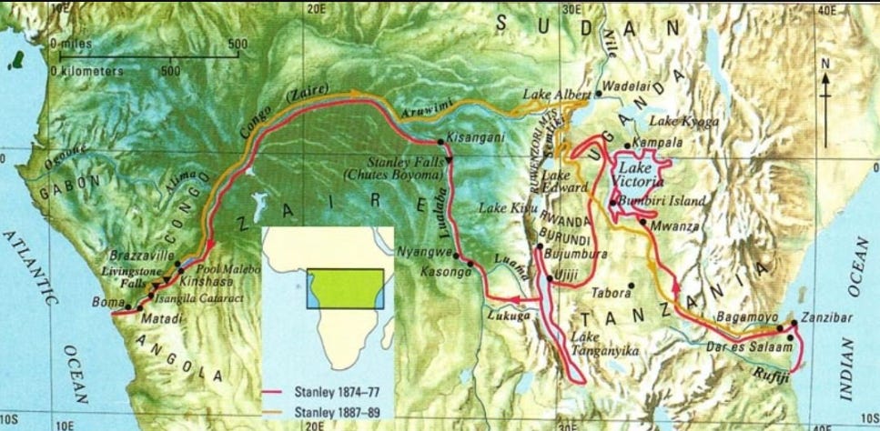
Journeys of H.M.Stanley.
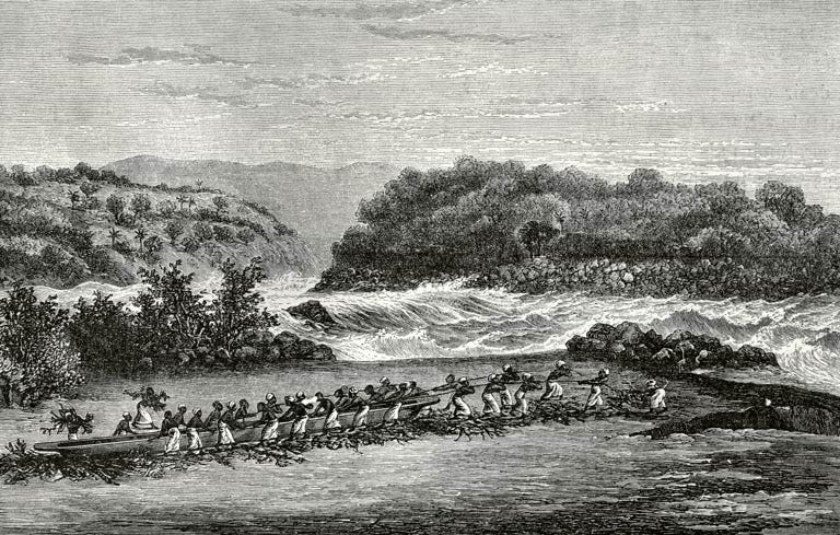
Expedition of Stanley. Dragging the canoes down the first waterfall of the Livingstone Falls, on the Congo River, c. 1887.
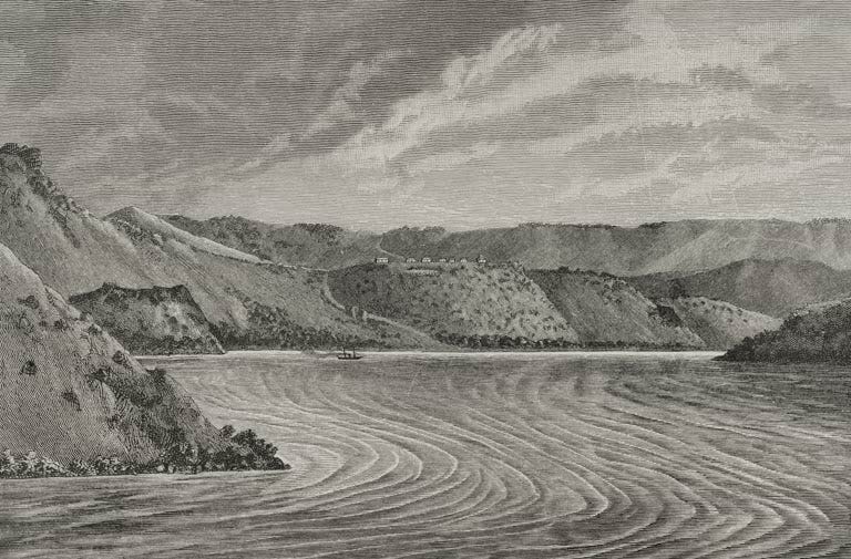
Vivi station on the Congo River, 1890.
Unfortunately, the history of the Congo’s riverine populations is known largely through accounts written by outsiders, most notably H. M. Stanley. A former Confederate soldier who had fought in the American Civil War, Stanley displayed extreme prejudice towards the Africans he encountered, attracting criticism even during his own lifetime.4
Just as the explorer John Speke had inaugurated the Hamitic myth in Eastern Africa, with consequences that would later prove devastating in Rwanda, H.M. Stanley’s writings entrenched the image of Africa as the “Dark” continent, and an antithesis of the Western World, laying the groundwork for King Leopold’s atrocities in Congo.5
The efforts of riverine communities to resist intruders were misrepresented as expressions of innate African “hostility.” These encounters helped reinforce negative stereotypes that became attached to particular African populations, obscuring the legitimate concerns underlying their resistance.
Yet the mistrust of these communities was ultimately vindicated by subsequent events. Stanley later returned to the Congo as a principal agent of Leopold II’s colonial project and heralded the infamous atrocities that ensued.
According to the historian Robert Harms, for the riverine communities, the upheavals of the colonial period ruptured the unbroken sequence of oral traditions that usually complement (external) written accounts in African historiography.6
The limitations of accounts written by explorers like Stanley are quite obvious and have been pointed out by several historians, anthropologists, and specialists in adventure and travel literature.
However, they also preserve some key aspects of the riverine societies before the colonial occupation (which effectively began in the 1890s), and, when critically examined, reveal the extent of local geographical knowledge and use of the river by Central African communities.
For the sake of brevity, this text will focus on the Congo River itself and the Lualaba tributary, only analysing a few of the riverine societies, and a handful of geographical references such as the Malebo Pool, Upoto, and the Boyoma Falls/Kisangani.
The Freight Canoes of the Congo River: Boatbuilding and Naval Warfare.
In his first visit, Stanley encountered African boatmen navigating the river along the entire course of the Congo River and its tributaries, many of whom guided his expedition.
The explorer managed to purchase, and in other cases, outright steal, dozens of large canoes for his journey downstream along the Lualaba to the Congo River and the Atlantic coast.7
The Lualaba is the main tributary of the Congo River. Its entire course was largely dominated by the Wagenya/Wenya boatmen, who, along with a few Zanzibari traders from the river port of Nyangwe, guided and guarded Stanley’s expedition.
Stanley describes them as such:
“The Wagenya are a remarkable tribe of fishers, who inhabit both banks of the Lualaba, from the confluence of the Kamalondo on the left bank down to the sixth cataract of the Stanley Falls.”8
A later account about the Wagenya by Sidney Langford in 1892/4 notes that “they are all free men, they have no slaves.” All ferrying up and down the Lualaba River was done by them in exchange for payment in kind. Curiously, he claims that they didn’t build their flat-bottomed canoes, but bought them from the pygmy peoples in the interior.9
Stanley’s party travelled downstream the Lualaba mostly by river, occasionally stopping to haul their canoes overland when they reached each set of rapids. After the Boyoma falls, the flow of the Congo River is unimpeded until Malebo Pool.
Uninterrupted riverine travel thus connected the communities along the banks of the Congo River.
For example, it was at Rubunga, not far from Upoto, that Stanley found Portuguese muskets on sale at a local market that had been brought upstream by ivory traders known as the Bangala, who’d bought them from other traders near the Atlantic coast. It was here that he was told that the river was called “Ikutu ya Kongo.”10
In the report on the navigability of the Congo and its tributaries, prepared during Stanley’s second visit from 1879-1884, he estimated that the Lower Congo was navigable for 100 miles until the cataracts, and the Upper Congo had a navigable length of 1068 miles.
Besides these were the tributaries, which brought the total of navigable waterways in the Congo basin to 5,249 miles.11
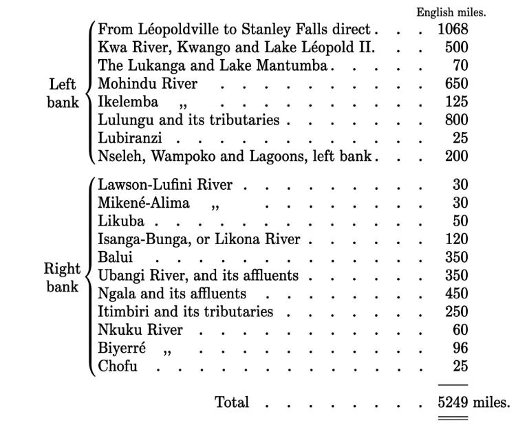
Table by H.M.Stanley, showing the navigable length of the Congo and its tributaries.
The main watercraft used for transportation, trade, and warfare on the Congo River and its tributaries were large, flat-bottomed canoes of varying lengths that could carry up to 80 paddlers and their cargo.
The freight canoes of the upper Congo River were the largest in Central Africa.
The enormous girth of the trees obtained from the surrounding forests allowed boatbuilders to carve the canoes directly from the trunk without the need to join individual planks using water-resistant compounds or caulking as in most river barges such as those used on the Niger River in West Africa.
Stanley describes them as “capacious, flat-bottomed scows, dug out of a fragrant gum-tree, which grows to very large dimensions in the forests.”12
The largest among these likely had a capacity of more than 10 tonnes, based on the number of men and cargo it could carry. The Zanzibaris later introduced dhows (medium-sized sailing ships from the Swahili coast), mostly on the Lualaba. European traders (and some Africans) on the Lower Congo also used ships, sail-boats and canoes.
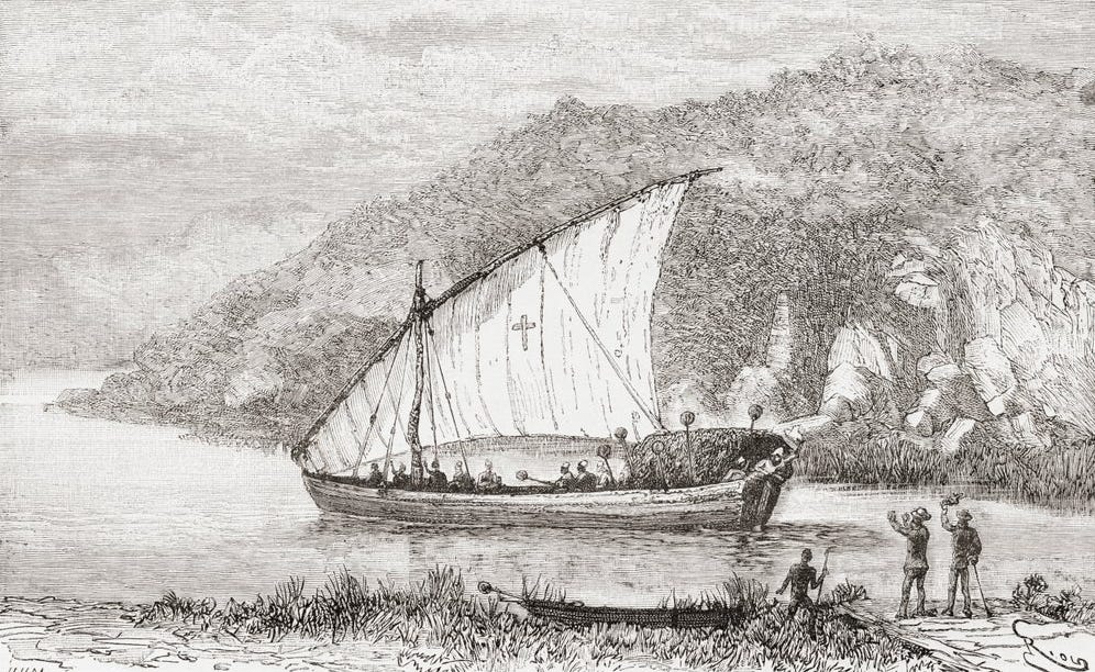
A dhow on the Congo River in the 19th century, from ‘Africa Pintoresca’, 1888
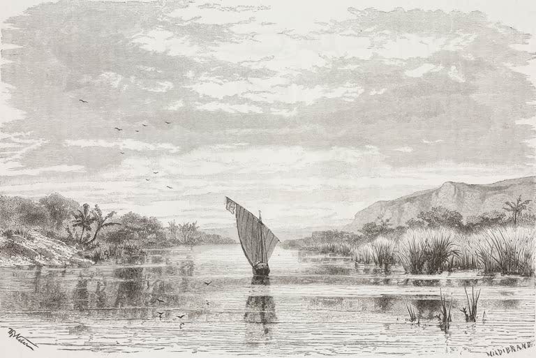
Entrance to the Lukuga River, Congo. Drawing from Verney Lovett Cameron, 1877.
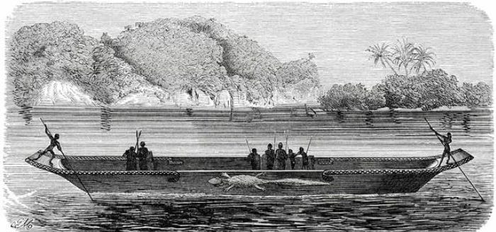
‘Mwana Ntaba Canoe (The “Crocodile”)’ From Henry M. Stanley, 1878
On the Upper Congo, some of the largest canoes belong to the Mwana Ntaba, near the Boyoma Falls. They measured about 85 ft long, had platforms on the bow and stern, and featured relief carvings of crocodiles and lizards.
The “century old antique” measuring 50 ft, which was found at Ikondu, along the Lualaba, indicates that boatbuilding traditions were of considerable antiquity.13 These “monstrous” vessels seem to have mostly been used for war, and one of them was captured by Stanley’s crew after a battle and was promptly manned by 30 of his crew.14
Perhaps the largest freight canoe, that could carry up to 100 men, was encountered at Umaneh along the upper Congo River during his second visit.
“A veritable Leviathan among canoes lay alongside the clay bank, and would require at least one hundred stout warriors to propel it at sufficient speed in a river-fight. The stern platform was of three-inch teak, while the bow was massive enough to sink a merchant ship. The empty canoe showed at least 30 inches of freeboard, and along its whole length were carved figures of crocodiles and fishes.”15
It was along the same river that a “large flotilla” consisting of 54 “monster” canoes was encountered, each carrying 80 paddlers, with a platform at the bow to carry ten men.
“All the paddles are headed with ivory balls, every head bears a feather crown, every arm shows gleaming white ivory armlets.” The canoes were longer than the 85-ft long canoes of Mwana Ntaba.16

‘Monster Canoe’ on the Upper Congo. From Henry M. Stanley, 1878
Stanley’s account indicates that naval battles were a long-established part of local military systems.
The navies grew larger downstream of Upoto, encounters became more frequent, and the battles more fierce, especially in the territory of the Bangala and Marunja, whose forces had as many as 70 large canoes armed with imported muskets.:
“The natives advanced on us in gallant style, and after firing their heavily charged guns withdrew rapidly again to re-load, and in the meantime the wooden assegais were launched with a marvellous dexterity, and the beautiful canoes skimmed about like flying-fish here and there with bewildering evolutions and wonderful velocity and grace.”17
Some of these massive canoes were stolen and repurposed by the colonial armies during their invasion in 1892/4:
Sidney Langford, who took part in the invasion, describes one on the river port of Farrhagis along the Lualaba River:
“These canoes, though simply dug out from a single tree, are a grand means of transport. The largest one carried sixty men to paddle; twelve soldiers with their kit and food; Mohun, his bed and luggage, in a house built on the canoe; the cook Philip and two or three other servants; together with a kitchen fire and a couple of milk goats, besides half a ton of stores. This canoe passed through the most extraordinary adventures without damage.”18
Ordinary canoes, used for both trade and fishing, were much more numerous, albeit often smaller.
For example, at the trading hub of Upper Yambinga not far from Upoto, Stanley counted over 1,300 canoes fastened to stakes in the river. The smallest of these was about 20ft long.19
The extensive boat-building traditions of the riverine communities and the size of their navies, some of which exceeded five thousand men20, demonstrate the importance of navigation on the Congo River in the emergence of organised society in the Central African interior.
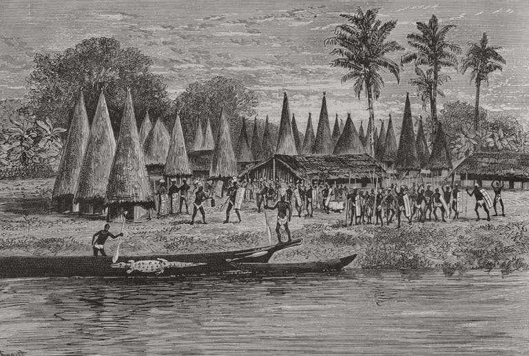
‘View of Bondeh’ Depicting a large canoe on the upper river. From Henry M. Stanley, 1885.
Also note the unusual architecture of conical huts surrounding the more common rectangular huts, the former of which Stanley suggested to have been a recent import likely from the Lower Congo.21
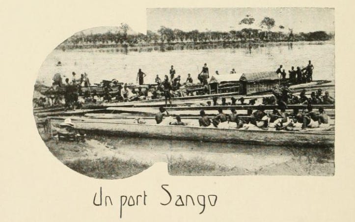
Canoes in the port of Sango. Illustration from ‘Le Congo illustré, 1891’
State and society along the Congo River: Fishing, Trade, and Incipient urbanism.
The inner basin on both sides of the great fold of the Congo, between the Sanga and the lower middle Congo to the west and the Lualaba to the east, lies within the belt of rainforests.
Its habitats consist of marsh and inundated forests of various sorts in its western half and of forests on dry land in the eastern half. Semideciduous, rather than evergreen, forests predominated in the south, where intercalary savannas were also especially important.
According to the historian Jan Vansina, no locality in the area was far from a navigable river, and the network of rivers facilitated travel over long distances.
This accounts in part for the huge area occupied by the closely related dialects or languages of the Mongo group, which span the whole inner basin south of the great Congo bend. The network also created strategic locations near the confluence of major river systems on the rare mounds that were high enough for village settlement.22
Linguists studying the more than 40 languages of the central Zaire basin were struck by the close linguistic relationship among them compared to the languages of the surrounding highland regions.
The languages fall into Zone C of the Bantu languages, forming a group which is more cohesive than any other in the Bantu-speaking zones. This cohesive linguistic zone suggests that the diverse peoples of the central basin have shared a historical experience distinct from that of their highland neighbors.23
Linguistic data suggests that the early speakers of the Zone-C may have spread to the Central Congo River Valley using canoes, likely using the Sanga River.
The need for canoes was probably even greater in the distant past than it is today. There is evidence that the climate of the central basin was more humid then, and much of the land is so flat that even a slight increase in the level of water could cause a significant extension of the swamps.
The iron-using C-speakers had an economy that mixed fishing with agriculture, based on plantains, yams, and later cassava. Trade between these communities intensified as populations grew.24
These mixed economies of fishing (mostly done by men) and farming (done by women) were described in Captain Vangele’s account of the communities near Upoto in 1889.
“Every morning two or three hundred canoes may be seen cutting their way through the water, carrying to their day’s labour in the fields women and children, with a few warriors to protect them. Their fishing deserves special notice.
Nowhere, except perhaps at Stanley Falls (Boyoma Falls), have I seen it carried on such a scale. Their traps are so heavy as to require for their transport two canoes lashed together. The laying down of these traps involves a sort of military ceremony; drums beat, and the different crews accompany each stroke of their paddles with a sharp, short cry.”25
About a decade earlier, in the region near the confluence of the Aruwimi below the Boyoma Falls, Stanley observed the construction, at low tide, of massive ditches cut at an obtuse angle to the river, as well as dams built over the falls, that were made of tree poles:
“The larger islands and banks exhibited proofs of that love of the natives for fish which has stimulated them to undertake these laborious excavations, often over a hundred yards in length, to plait huge basket traps and reedy fences at the mouths of creeks, to manufacture coils of stout rope out of plantain and palm (Hyphene) fibre, large cord nets, to plant great poles in the middle of cataracts, and, undeterred by its dangers, to risk their lives daily in fish-catching.”26
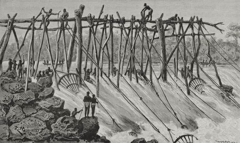
Fishing At Stanley Falls. Sketch by M. Louis Amelot. From ‘Stanley’s Emin Pasha expedition’ by A.-J. Wauters, 1890
According to Vansina, during the late 1st to early 2nd millennium CE, trade in the early, small-scale riverine societies of the upper Congo mostly consisted of commodities such as farm produce, metals, metal objects, salt, fish and seafood, raffia cloth, pottery, canoes, camwood powder, palm oil, perhaps mats and baskets, and a few rare luxury items such as conus shells and rare furs.
Pawns existed at this stage, but not slaves, who arose later with the rise of more complex polities including centralised kingdoms and chiefdoms by the 13th century in the Lower Congo (eg Kongo, Loango, and Tio), and after the 16th century in the Upper Congo.27
[On pre-colonial states in this region, see my previous article titled “Africa Was Not an Anarchist Paradise” ]
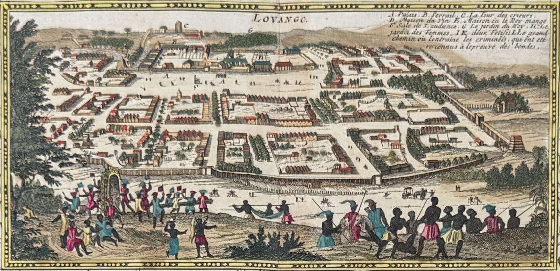
The city of Loango. Taken from ‘View of Loango & Congo, Africa’ by Henri Abraham Chatelain 1718, based on engravings of Olfert Dapper, 1668.
In most of the Upper Congo basins and its tributaries, these larger, complex societies were organised on the level of chiefdoms and ‘districts’, but more commonly as ‘firms’ and often less centralised than those in the Lower Congo.
The largest comprised multiple settlements ruled by a founding ‘House’, and could field significant armies of spearmen and canoemen. Military success depended on numerical superiority. Huge war canoes were loaded with 40 and sometimes even twice that many spearmen.28
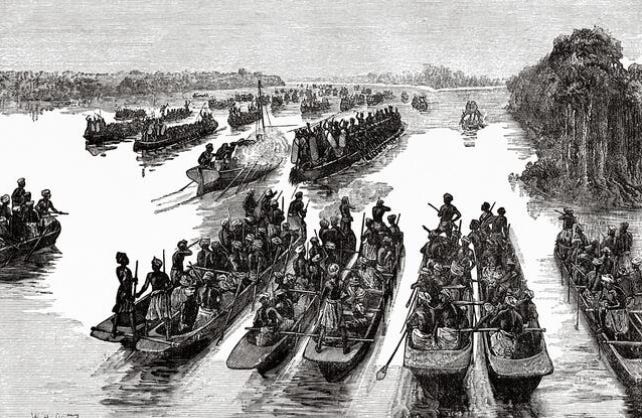
‘The fight below the confluence of the Aruwimi and the Livingstone rivers’ from H.M. Stanley, 1878
The more common ‘firms’ consisted of different groups of carriers who carved out commercial spheres for themselves along the river; each of them fiercely defended their segment of the river
Competition and warfare were rife between them, no doubt contributing to the “hostility” witnessed by Stanley, and made more infamous in later accounts. Yet such conflict didn’t impede trade, nor the formation of large towns or agglomerations, made up of competing firms that were held together by the need for common defence.29
While mostly found in the Upper Congo, such ‘incipient urban’ settlements could be found as far south as the Lualaba.
Stanley first encountered such a town at Ikondu on the Lualaba, which consisted of “a remarkably long village, or rather a series of villages, from fifty to a hundred yards apart, and a road, uniform street, thirty feet wide, and two miles in length !”
It had a population of about 2,000, living in rectilinear houses built with palm wood with gable roofs. In the town were gardens of cassava, palm trees, bananas, melons, groundnuts, and sugarcane. The occupants reportedly abandoned the town as Stanley’s caravan approached, wanting little to do with the outsiders.30
The architectural layout of these settlements, some of which possessed “lateral and transverse streets at right angles,”31 often running east to west, fascinated the explorers, who considered them an unusual site in the interior of Africa, and at times compared them to those in Egypt.
Stanley describes one such large town of the Wagenya, with a population of 6,000 located near the 7th cataract of the Boyoma falls, that was arranged in a way “resembling a town on the Upper Nile.”
The town was also abandoned just before Stanley’s arrival. It consisted of a “cluster of villages” separated by short distances, “each possessed four or five streets 30 feet wide, running in parallel lines, with cross alleys leading from one side of the village to the other.”32
Other accounts indicate that this architectural layout wasn’t unique to the riverine communities but could be found as far south as Manyema, where Cameron Lovett, in 1875, describes native houses arranged in long parallel streets:
“For some days we journeyed through a fairly populated country, with large villages of well-built and clean huts disposed in long streets, with bark-cloth trees planted on each side. All the streets ran east and west, but the reason for this custom I was unable to discover.”33
Even small settlements with the population of a few hundred followed the same arrangement:
Herbert Ward in 1890 described a similar layout at Monsolé in the Lower Congo region, in which “houses are built in two parallel lines, with a large, open, well-kept street between them.”34
Deep inland along the edge of the Ituri forest in the mountains to the west of Lake Albert, Stanley found (and illustrated) a small settlement of Bakwuru, arranged along a straight street about 40ft wide.
Travelling along the Aruwimi tributary of the Congo River, Stanley found many slightly larger settlements at the edge of the “primeval” forest, one of which consisted of “a long, orderly arrangement of a street 33 feet wide, flanked by four low blocks of buildings 400 yards in length.”35
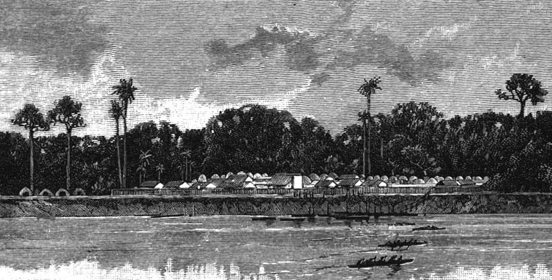
“A typical village on the lower Aruwimi”, Congo. Illustration from H.M.Stanley, 1890
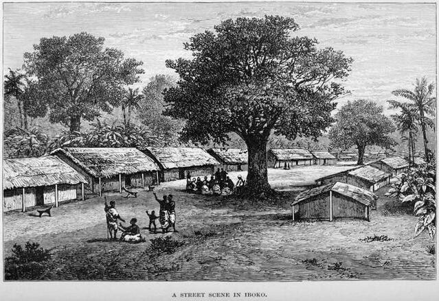
‘A street scene in Iboko’ Illustration from H.M.Stanley, 1885
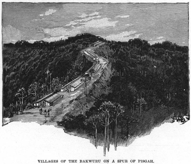
“Villages of the Bakwuru on a spur of Pisgah”, Congo. Illustration from H.M.Stanley, 1890
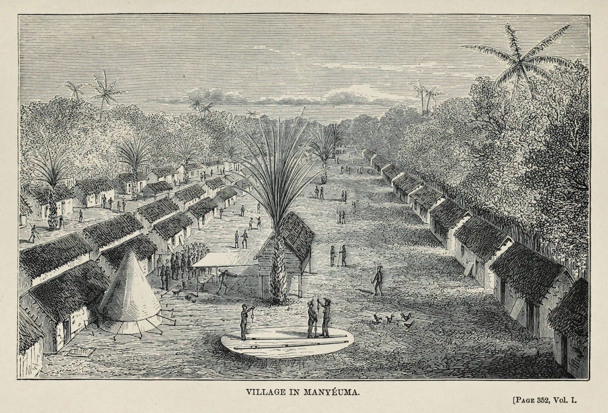
Village in Manyéuma (Manyema/Maniema), Congo. Illustration from Verney Lovett Cameron, 1877.
While the largest of these ‘incipient’ urban settlements, such as Isangi (the pre-Arab town with a population of about 12,00036), could not have rivaled the great capitals of Kongo and Loango at their height in the 17th century; they were about the size of the smaller East African cities like Mombasa and Mogadishu in the 19th century.
The tendency to withdraw from the towns was interpreted by the explorer as a peculiar practice unique to the peoples of the interior when faced with the threat of slave raids by the Zanzibari ivory traders.
However, such temporary withdrawals from towns into the interior in order to organise a counter-attack seem to have been a common method of defence in the region, and are even documented in the medieval Swahili towns of the coast as well, during the 16th-century invasions of Mombasa and Kilwa.
An example of this defensive tactic was documented for the inhabitants of Vinyanjara, along the Lualaba, who abandoned their town upon the arrival of Stanley’s caravan in order to mount their attack, consisting of “large flotilla of canoes” with about 800 spearmen.37
Along the Congo River and most of its Lualaba tributary were several market towns, entirely controlled by natives, that were considered neutral grounds by all parties, and represented the older economic exchanges of most of the river basin:
“These market-places on the banks of the Livingstone (Congo), at intervals of three or four miles, are central resorts of the aborigines from either bank, and considered as neutral ground, which no chief may claim, nor any individual assert claims or tribute for its use.
Many of them are wide grassy spaces under the shade of mighty spreading trees, affording admirable river scenes for an artist. In the background is the deeply black forest, apparently impenetrable in its density.
From the depths of the forest, and from isolated clearings, from lonely islands, and from the open country of the Bakusu, come together the aborigines with their baskets of cassava, their mats of palmfibre and sedge, their gourds of palm-wine, their beans and maize, millet and sugar-cane, crockery and the handiwork of their artisans in copper and iron and wood, the vermilion camwood, their vegetables, and fruit of banana and plantain, their tobacco and pipes and bangles, their fishnets and baskets, fish, and a multitude of things which their wants and tastes have taught them to produce.”38
On the upper Congo River, an example of a large market was the one found at Rubunga, not far from Upoto, to which a variety of goods were brought in “light, swift, elegant canoes, of the caique pattern.”
Besides the Portuguese muskets mentioned above, the most interesting article of trade was the curved daggers, which Stanley describes as “singular specimens of the African smith’s art.”39
The use of canoes to transport goods between different markets was frequently reported along most of the river. The dependency on riverine transport was to such an extent that many of these largest markets and settlements were in fact located on islands within the river.
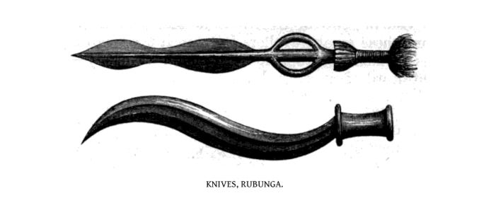
Knives, Rubunga. From Henry M. Stanley, 1878
The Converging Influences of External Trade: Europeans in the Lower Congo and Zanzibaris on the Lualaba.
16th-century European geographers, using information provided by traders and missionaries, thought the Congo flowed from the same source as the Nile.
The Africans of the upper river, for their part, remained aloof from European political and cultural influences despite an active Portuguese and later Dutch presence around the lower Congo.
Although the coastal societies and those in the upper Congo remained physically and culturally isolated from one another, they nevertheless forged indirect ties through trade, mainly in ivory, captives, textiles, and copper.
In the Lower Congo below the Malebo Pool and in some sections upstream, Long-distance trade networks were established by the 16th century, principally in luxury items such as copper and camwood, the latter of which is used as a cosmetic.
Although camwood trees grew in the forests above the Pool and in the regions near the coast, they were not found in the area of the Pool itself, where camwood is documented by 1698. Copper was mined in the lower Congo region and may well have found its way into the trading circuits along the upper river.40
Because the central Congo basin was beyond the ambit of the Atlantic economy, the traders of the upper river enjoyed a strong bargaining position, selling only if the price was right.
During the 16th and 17th centuries, they participated only intermittently in external trade in slaves in the Malebo Pool. This trade expanded briefly in 1529 but rapidly declined after 1560 as the Portuguese moved their base to Luanda in Angola. Most slaves were drawn from the savanna region south of the Pool, with few, if any, coming from the Tio and the upper river.
Duarte Lopes, who was in Kongo from 1579-83, reported that there was little trade between the Portuguese and the Tio. Father Jéréme de Montesarchio, who visited the Pool in 1655, did not mention any slave trading there. When da Caltanisetta visited the Pool in 1698, he was informed that trade would be reestablished after peaceful conditions resumed, implying that they had not been coming in the recent past.41
This trade doesn’t seem to have expanded significantly inland along the upper river. Geographical knowledge of the interior by European traders extended only as far as the river upstream of the Alima tributary of the Congo River, where the kingdom of Ibare appears in documents from 1612 and 1620.42
There was a rise in slave exports from Loango during the 1780s, with some apparently coming from the upper river. At Loango in the 1780s, one-sixth of the slaves came from the Bobangi merchants just north of Tio; one-fourth were Tio, and the rest came from near Loango. In later years, some would come from as far away as the Ubangi tributary.43
The abolition of slavery and the rise of legitimate commerce (mostly in Ivory, Rubber, and Palm Oil) fueled an unprecedented demand for commodities from the interior that, unlike previous exchanges, left a profound impact on the riverine communities.
As the ‘barter terms of trade’ became increasingly favorable, the economy of the upper Congo River became more oriented toward international trade, especially in ivory.
At the Portuguese colonial capital of Luanda in Angola, the price of ivory shot up 300% in 1836 after the government abolished its monopoly on ivory. Ivory exports rose from a ton and a half in 1832 to over eighty tons in 1859. In the city of Zanzibar on the East African coast, the price of ivory rose 400 percent between 1823 and 1873.
The rising prices at the coast made the transportation of significant quantities of ivory from the far interior profitable and activated a massive growth in the ivory trade in the central Congo basin.
Although ivory had long been used by the inhabitants of the upper river for bracelets, hairpins, and pestles, its value within the basin itself was relatively low. Traders who went into an area where the value of ivory at the coast was unknown could reap enormous profits; consequently, there was a rush for ivory in the central Congo basin from both sides of the continent.44

Side-blown ivory Oliphant from the kingdom of Kongo, ca. 1552, Treasury of the Grand Dukes, Italy.
Writing in the 1880s, the missionary Armand Merlon estimated that 300 tons of ivory annually arrived at the Malebo Pool in the 1880s, but Jan Vansina estimates that half that amount would be more accurate.
Much of this ivory came from the upper Congo River and its tributaries in what is today northwestern D.R.C., where a number of groups participated in this trade.
The Bakanga and Akula of the upper Mongala were famous ivory hunters. The major source on the upper Ubangi River was the Bonjo, who traded it to the Loi, who introduced it into the Congo River trade.
The Maringa-Lopori basin also produced enormous quantities of ivory; in 1886 a European trader on the upper Maringa bought two tons in one day. South of the forest, Likwala ivory was furnished by Mboshi hunters to the Likwala river people, who carried it downstream to the Congo River.45
The existence of powerful centralised kingdoms around the Lower Congo, as well as the cataracts, initially deterred the expansion of European traders into the interior from the West, thus keeping both the ivory and rubber trade in African hands.
[see my previous essay: Beyond king Leopold’s ghost: Rubber trade and economic growth in the Kongo and Ovimbundu kingdoms (1870-1910) ]
On the eastern side of the continent, however, were small-scale societies linked by the commercial networks of the Nyamwezi carriers in present-day Tanzania, which were soon taken over by the Arab and Swahili caravaneers from Zanzibar.
Zanzibari ivory traders, who were chasing the ivory frontier inland, established their base at Nyangwe on the Lualaba River in 1868, which in Stanley’s time was their furthest settlement inland.
Just like the town of Isangi mentioned above, Nyangwe may have been a significant settlement before the arrival of the “Arabs.”
It was ruled by Muini (Mwinyi/Lord) Dugumbi, described as a “half-caste” “negroid” who founded the town in 1868, and Sheikh Abed, both of whom were assisted by several “Arabs”, “Waungwana” (Swahili), as well as the Wagenya and Wanyema, who were the natives.
Nyangwe had a large daily market, mostly for agricultural produce, as well as cloth, livestock and metalwork. About 3,000 local traders came from across the region, wearing “the fabrics of Manyema, which are beautifully coloured and very durable.”
“And how like any other market-place it was! With its noise and murmur of human voices the aborigines of Manyema possess just the same inordinate ideas in respect to their wares as London, Paris, and New York shopkeepers.”46

Ruins of a mosque in Isangi, eastern D.R.Congo, ca. 1894. NMVW.
The arrival of the Zanzibari traders inaugurated a period of social upheaval that would be greatly surpassed by the Belgian colonists, led by Stanley himself.
Despite how passionately Stanley (and other colonialists) condemned the ruinous actions of the Zanzibaris in 1883, he appointed their leader, Tippu Tipp, to the colonial administration in 1887 as a governor of the Eastern provinces.47
Stanley’s successors also retained many of the “Arabs” in administration even after they had defeated them in the so-called Congo-Arab war of 1892-1894.48
The last Zanzibari officials were not dismissed until c. 1920!49
Nevertheless, the military strength and commercial influence of the Zanzibaris shouldn’t be overstated, especially in the early years between 1868 and Stanley’s second visit in 1883, when their population was still small.
Stanley’s Arab hosts at Nyangwe in 1876 recounted an expedition to obtain ivory in the “dwarf country” beyond the Lualaba River that was nearly wiped out by the poisoned arrows of the armies of the pygmies, even though the Arabs were armed with muskets. This defeat forced the Zanzibaris to abandon any plans of expansion beyond the river.50
In another region downstream of the Lualaba at the market town of Ukongeh (near Kindu), which was settled by the ba-Kusu, Stanley notes that “The Arabs, each time they have attempted to penetrate Ukusu, have been repulsed with slaughter.”51
The Zanzibaris did eventually muster enough forces to attack the settlements along the entire river up to Boyoma Falls, mostly by building local alliances. At the time of Stanley’s second visit in 1883, they had devastated all river settlements as far as Isangi, though these were quickly rebuilt by the natives, who’d temporarily retreated inland.
At this time, Stanley, who was working for King Leopold II, founded the colonial station of Stanleyville, i.e., Kisangani. Four years later, he appointed Tippu Tipu, effectively helping the Arabs complete their conquest of the Eastern Congo.
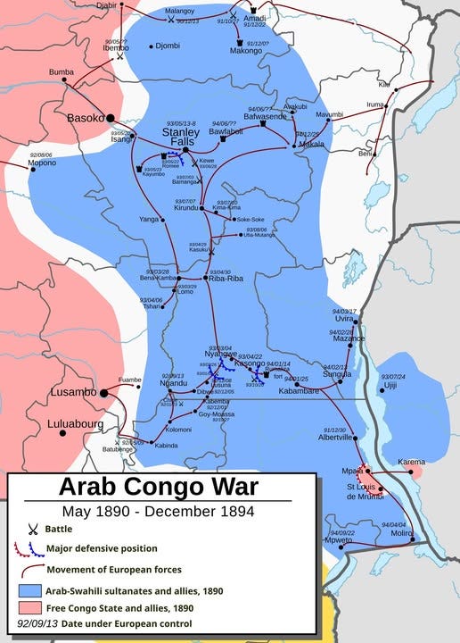
The Congo-Arab War, map by Daniel López
But before the late 1880s, the riverine economies of the interior, from Malebo Pool to Boyoma Falls, and as far upstream as Nyangwe, remained firmly under local control.
In this region, commercial boundaries between competing firms did not impede the development of commercial diasporas or “trading peoples”.
It’s important to note that ethnic identities and their spatial distributions change over time, so many of the groups described in these early accounts have adopted new identities or been absorbed into other groups.52
This map below by Vasina captures some of the most prominent riverine trading groups as they were later known in the 20th century.
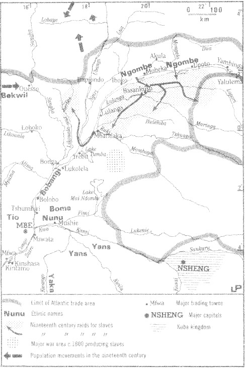
An example of these trading peoples were the Ikengo, who, by Stanley’s first visit in 1876/7, were already carrying out a brisk trade in textiles, brass and ivory upstream, from the Malebo Pool to the territory of the Bangala.53
Another group, briefly mentioned by Stanley but better described by later accounts like Herbert Ward in 1888, were the Bateke, who were known as a “trading people” (ie; merchants); their canoes, laden with goods, were observed travelling upstream, from the borders of the Kongo kingdom, and terminated near the Bangala territory as well.
“A number of canoes filled with Bateke people, and laden with peanuts and corn, passed us going up the river, hugging the shore.
Being the great trading community of the Lower Congo, situated at Stanley Pool (Malebo Pool), their position as traders is a naturally good one, and they have not been slow to avail themselves of it.
They have constituted themselves the middlemen between the ivory-trading tribes from the Upper Congo and the Bakongo of the Lower River, and reap substantial profits as the result of their self-imposed mediation.”54
Lastly were the Irebu near Lake Tumba, whose “large settlement or cluster of towns” was affectionately called the “Venice of Africa” by Stanley during his second visit.
The Irebu operated upstream as far as the Boyoma falls, having reportedly “taught the fierce Bangala to treat their traders with respect.” They therefore opened the entire trade of the upper Congo River to their merchants by breaking the only major commercial boundary between the Pool and the Falls.
“These people were really acquainted with many lands and tribes on the Upper Congo. From Stanley Pool (Malebo Pool) to Upoto, a distance of 600 miles, they knew every landing-place on the river banks.
They knew the varied lengths of the sina (“long” of cloth), the number of matako (brass rods) they were worth… they could tell, by poising on the arm, what profit on an ivory tusk purchased at Langa-Langa would be derived by sale at Stanley Pool!
No wonder that all this mercantile knowledge had left its traces on their faces; indeed it is the same as in your own cities of Europe. Know you not the military man among you, the lawyer or the merchant, the banker, the artist or the poet? It is the same in Africa, more especially on the Congo, where the people are so devoted to trade.”55
This indigenous river trade came to an abrupt halt in the 1890s.
‘In the wake of Stanley’s discovery that the central Zaire basin contained an important network of navigable waterways, Belgian King Leopold II’s International African Association formally annexed the Congo in 1885, creating the Congo Independent State.
By 1891, the State was strong enough to begin military campaigns against the African traders in order to increase commercial opportunities both for European companies that were installing themselves in the area and for the Congo State itself.
By the beginning of the twentieth century, the river trade was solidly in European hands, and the African traders were reduced to smuggling.’56
The Congo river remains a vital waterway and tourist attraction.
A ferry service taking passengers from Kisangani to Kinshasa (Malebo Pool) was established as early as 1894, when it was documented by the East African caravanner Abdallah bin Rashid, and the German Count Gustav Adolf von Götzen , and remains in use today.
Like many colonial innovations, this ferry service was built upon pre-existing traditions of travel and trade, often utilising the same watercraft and riverine peoples that dominated the Congo waterways during the pre-colonial period.
Given the relative scarcity of highways in the interior, and the vast size of the country, the Congo river network functions as the primary “highway system” for moving people and heavy goods from the interior forests and mines to global markets.
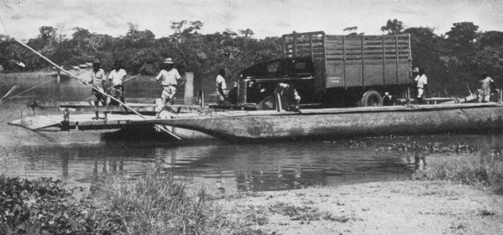
‘Ferry across the Ituri river near Avakubi, about 200 miles east of stanelyville’ c. 1949. Belgian colonial period.57
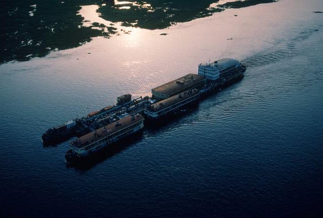
Barge on the Congo river. Alamy Images.
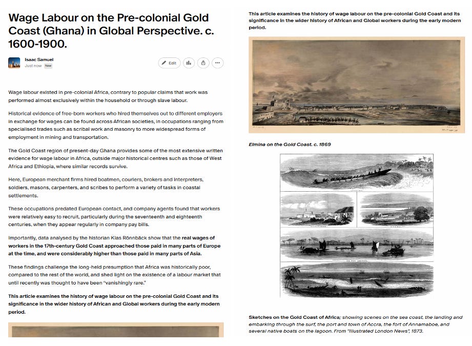
Wage labour existed in pre-colonial Africa, contrary to popular claims that work was performed almost exclusively within the household or through slave labour.
A recent study of wages paid to uskilled labourers on the pre-colonial Gold Coast (modern Ghana), found that the real wages of African workers approached those paid in many parts of Europe at the time, and were considerably higher than those paid in many parts of Asia.
The History of Wage Labour on the Pre-colonial Gold Coast is the subject of my latest Patreon Article;
Please subscribe to read more about it here and support this newsletter:
Paths in the Rainforests: Toward a History of Political Tradition in Equatorial Africa by Jan Vansina, pg 43
River of Wealth, River of Sorrow: The Central Zaire Basin in the Era of the Slave and Ivory Trade, 1500-1891, by Robert W. Harms, pg. 2
River of Wealth, River of Sorrow: The Central Zaire Basin in the Era of the Slave and Ivory Trade, 1500-1891, by Robert W. Harms, pg. 2-3
Henry Morton Stanley and His Critics: Geography, Exploration and Empire by Felix Driver. Victorians and Africans: The Genealogy of the Myth of the Dark Continent by Patrick Brantlinger. Stanley: Sorcerer’s Apprentice by Frank McLynn.
Building Congo, Writing Empire: The Literary Labours of Henry Morton Stanley by Jeffrey Murray. King Leopold’s Ghost: A Story of Greed, Terror, and Heroism in Colonial Africa by Adam Hochschild.
River of Wealth, River of Sorrow: The Central Zaire Basin in the Era of the Slave and Ivory Trade, 1500-1891, by Robert W. Harms, pg. 7-13.
Through the Dark Continent, or The Sources of the Nile, Vol. 2, by H.M. Stanley, published by Sampson Low, 1878, pg 153-155, 186-187
Through the Dark Continent, or The Sources of the Nile, Vol. 2, by H.M. Stanley, published by Sampson Low, 1878, pg. 123
The Fall of the Congo Arabs by Sidney Langford, published by Methuen & Co, 1898, pg 157-158
Through the Dark Continent, or The Sources of the Nile, Vol. 2, by H.M. Stanley, published by Sampson Low, 1878, pg. 283, 286
The Congo and the founding of its free state; a story of work and exploration, Vol 2, by H.M. Stanley, published by Harper & Brothers, 1885, pg 346
Through the Dark Continent, or The Sources of the Nile, Vol. 2, by H.M. Stanley, published by Sampson Low, 1878, pg 260
Through the Dark Continent, or The Sources of the Nile, Vol. 2, by H.M. Stanley, published by Sampson Low, 1878, pg 171, 219
Through the Dark Continent, or The Sources of the Nile, Vol. 2, by H.M. Stanley, published by Sampson Low, 1878, pg 219-220, 273
The Congo and the founding of its free state; a story of work and exploration, Vol 2, by H.M. Stanley, published by Harper & Brothers, 1885, pg 124-125
Through the Dark Continent, or The Sources of the Nile, Vol. 2, by H.M. Stanley, published by Sampson Low, 1878, pg 270-271, 273
Through the Dark Continent, or The Sources of the Nile, Vol. 2, by H.M. Stanley, published by Sampson Low, 1878, pg 292, 296
The Fall of the Congo Arabs by Sidney Langford, published by Methuen & Co, 1898, pg 252
The Congo and the founding of its free state; a story of work and exploration, Vol 2, by H.M. Stanley, published by Harper & Brothers, 1885, pg 109
The Congo and the founding of its free state; a story of work and exploration, Vol. 2, by H.M. Stanley, published by Harper & Brothers, 1885, pg 137
The Congo and the founding of its free state; a story of work and exploration, Vol. 2, by H.M. Stanley, published by Harper & Brothers, 1885, pg 126
Paths in the Rainforests: Toward a History of Political Tradition in Equatorial Africa by Jan Vansina, pg 101-104
River of Wealth, River of Sorrow: The Central Zaire Basin in the Era of the Slave and Ivory Trade, 1500-1891, by Robert W. Harms, pg 18
River of Wealth, River of Sorrow: The Central Zaire Basin in the Era of the Slave and Ivory Trade, 1500-1891, by Robert W. Harms, pg 19-23
Explorations on the Welle-Mobangi River by Captain Vangele, pg 327
Through the Dark Continent, or The Sources of the Nile, Vol. 2, by H.M. Stanley, published by Sampson Low, 1878, pg 268
Paths in the Rainforests: Toward a History of Political Tradition in Equatorial Africa by Jan Vansina, pg 94, 115
Paths in the Rainforests: Toward a History of Political Tradition in Equatorial Africa by Jan Vansina, pg 107-113, 225-229
Paths in the Rainforests: Toward a History of Political Tradition in Equatorial Africa by Jan Vansina, pg 225-229
Through the Dark Continent, or The Sources of the Nile, Vol. 2, by H.M. Stanley, published by Sampson Low, 1878, pg 169-170
Through the Dark Continent, or The Sources of the Nile, Vol. 2, by H.M. Stanley, published by Sampson Low, 1878, pg 260
Through the Dark Continent, or The Sources of the Nile, Vol. 2, by H.M. Stanley, published by Sampson Low, 1878, pg 249
Across Africa by Verney Lovett Cameron, Harper & Brothers, 1877, pg 245, 281
Five years with the Congo cannibals: By Herbert Ward, pg 113
In darkest Africa: or, The quest, rescue and retreat of Emin, Governor of Equatoria, by H.M. Stanley, Vol. 1, published by Sampson Low, 1890, pg 276-277, 283-284
The Congo and the founding of its free state; a story of work and exploration, Vol. 2, by H.M. Stanley, published by Harper & Brothers, 1885, pg 169-170
The Congo and the founding of its free state; a story of work and exploration, Vol. 2, by H.M. Stanley, published by Harper & Brothers, 1885, pg 184
Through the Dark Continent, or The Sources of the Nile, Vol. 2, by H.M. Stanley, published by Sampson Low, 1878, pg 167
Through the Dark Continent, or The Sources of the Nile, Vol. 2, by H.M. Stanley, published by Sampson Low, 1878, pg 284-285
River of Wealth, River of Sorrow: The Central Zaire Basin in the Era of the Slave and Ivory Trade, 1500-1891, by Robert W. Harms, pg 25
River of Wealth, River of Sorrow: The Central Zaire Basin in the Era of the Slave and Ivory Trade, 1500-1891, by Robert W. Harms, pg 25-27
Paths in the Rainforests: Toward a History of Political Tradition in Equatorial Africa, by Jan Vansina, pg 360-361, n. 10
River of Wealth, River of Sorrow: The Central Zaire Basin in the Era of the Slave and Ivory Trade, 1500-1891, by Robert W. Harms, pg 4, 28
River of Wealth, River of Sorrow: The Central Zaire Basin in the Era of the Slave and Ivory Trade, 1500-1891, by Robert W. Harms, pg 22-23
River of Wealth, River of Sorrow: The Central Zaire Basin in the Era of the Slave and Ivory Trade, 1500-1891, by Robert W. Harms, pg 41
Through the Dark Continent, or The Sources of the Nile, Vol. 2, by H.M. Stanley, published by Sampson Low, 1878, pg 177-122.
The Congo and the founding of its free state; a story of work and exploration, Vol. 2, by H.M. Stanley, published by Harper & Brothers, 1885, pg 139-161,
King Leopold’s Ghost: A Story of Greed, Terror, and Heroism in Colonial Africa by Adam Hochschild, pg 130-131. A near-contemporary account and critique of Stanley’s and the colonial government’s dealings with Tippu Tip can be found on pg 217-223 of Herbert Ward’s pejoratively titled ‘Five Years with the Congo cannibals’ (1890)
Paths in the Rainforests: Toward a History of Political Tradition in Equatorial Africa, by Jan Vansina, pg 240
Through the Dark Continent, or The Sources of the Nile, Vol. 2, by H.M. Stanley, published by Sampson Low, 1878, pg 104-107
Through the Dark Continent, or The Sources of the Nile, Vol. 2, by H.M. Stanley, published by Sampson Low, 1878, pg 168
Paths in the Rainforests: Toward a History of Political Tradition in Equatorial Africa, by Jan Vansina, pg 19-20
Through the Dark Continent, or The Sources of the Nile, Vol. 2, by H.M. Stanley, published by Sampson Low, 1878, pg 305
Five Years with the Congo cannibals: By Herbert Ward pg 247-248
The Congo and the founding of its free state; a story of work and exploration, Vol. 2, by H.M. Stanley, published by Harper & Brothers, 1885, pg 22-23
River of Wealth, River of Sorrow: The Central Zaire Basin in the Era of the Slave and Ivory Trade, 1500-1891, by Robert W. Harms, pg 7
The Belgian Congo: Impressions of a Changing Region, by Robert L. Pendleton